Printable guide
Fuerte de San Miguel, Campeche: Fort & Maya Museum Guide
Published
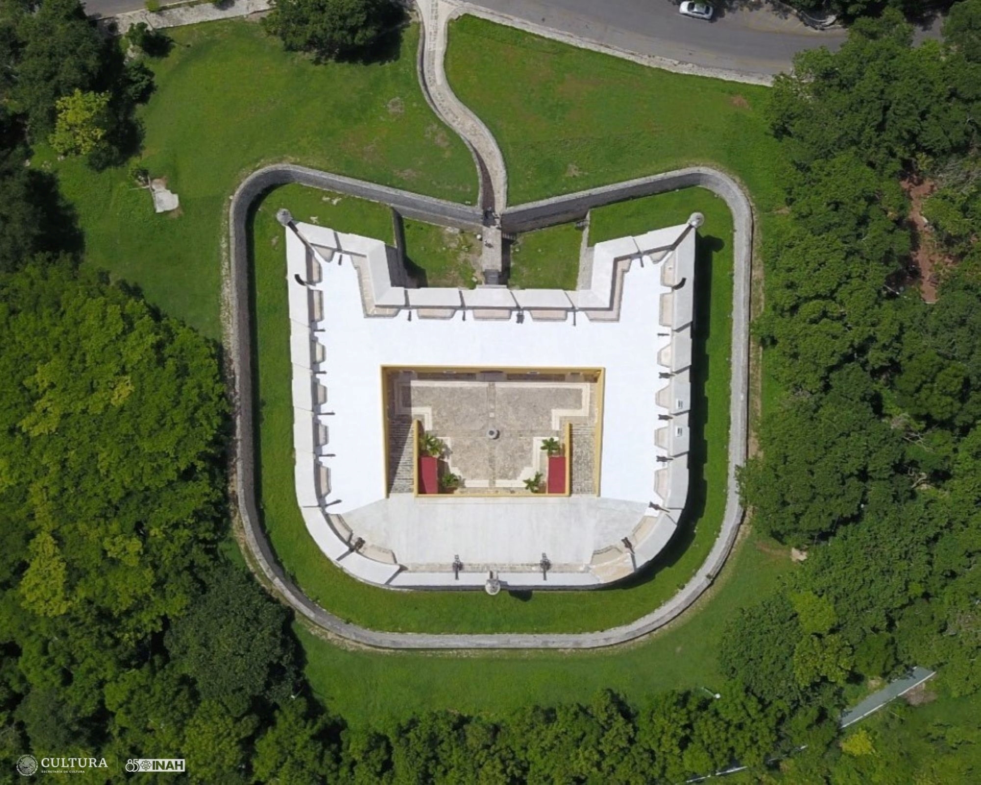
Why Fuerte de San Miguel belongs on your Campeche itinerary
Fuerte de San Miguel is both a fortification and the home of the Museo de Arqueología Maya in San Francisco de Campeche. It sits on a rise west of the walled historic centre, above the road toward Lerma, with a broad view toward the Gulf. The visit works because the building and the collection explain two different parts of Campeche at the same time: the Spanish colonial port that needed heavy coastal defences, and the Maya cities whose objects now form the state’s most important archaeological displays.
That combination makes the fort more worthwhile than a quick photo stop. You can study a gate, ditch, ramp, parapet, and lookout, then move inside to see material connected with Calakmul, Jaina, Uxul, and other Maya sites. The museum is not a substitute for visiting those places in the landscape. It is a useful introduction to their political world, art, burial practices, and regional connections before you travel farther into Campeche State.
Fuerte de San Miguel on the hill above Campeche City
Plan on roughly two hours if you read the displays and spend time on the fortifications. A faster visit can be done in about an hour, but that usually means treating the museum as a sequence of cases rather than understanding what you are seeing. Add travel time from the centre and a second nearby stop if you are building a half-day outing. The site is not inside the pedestrian grid, and the climb, bright sun, and heat make it less comfortable to rush through at midday.
For an independently planned visit, start with the current INAH visitor information for the Museo de Arqueología Maya, Fuerte de San Miguel. If you would rather have context while walking through the walled city and the fort, compare Campeche City tours on GetYourGuide and check Viator’s Campeche sightseeing inventory. Inventory and departure days change, so use the listings to confirm what is actually operating rather than assuming every city tour includes the fort.
GuideBastions of Campeche: San Carlos, San Francisco, San Pedro, Santa Rosa & SantiagoExplore
Where the fort is and how to reach it
The official address is Avenida Escénica s/n, in the Buenavista area of San Francisco de Campeche. The approach is from the Campeche–Lerma road and Avenida Escénica, not through the old city gates. On a map, the fort is southwest of the historic centre and close to the coastal side of the city’s southern approach. That geography matters: a walk from the centre is possible for a determined visitor, but it is not the same kind of short, shaded stroll as moving between Calle 59, the main square, and the bastions inside the walls.
A taxi or app-based ride is the simplest option if you are staying in the centre and want to arrive without spending energy on the road. Ask for Fuerte de San Miguel or Museo de Arqueología Maya. Show the Spanish name on your phone if needed. Keep the return journey in mind: the site has parking, but you should not assume a taxi will be waiting at the gate. Arrange a pickup, save the location, or return toward a busier road before looking for another ride.
If you have a rental car, the fort is straightforward to combine with other city sights, but do not treat its access road as part of the historic-centre walking route. Follow the current road signs and your navigation app, and allow extra time for traffic, road works, and a slow departure after closing. The official INAH listing describes arrival by public transport or private vehicle via the Campeche–Lerma road and Avenida Escénica. It is the right reference for access; online map pins and older guidebooks can use different wording for the same complex.
Public transport can be practical for residents and budget travellers, but routes and stopping patterns are less useful to visitors than a short taxi ride. Confirm locally before setting out, especially on a Sunday, public holiday, or a day when you are carrying a camera bag. A bus that takes you along the main road may still leave you with a walk in open sun. If you choose this option, ask the driver or a local passenger to confirm the closest stop for the fort before boarding.
The site is a better first stop than a final stop if you are visiting during the hottest part of the day. There is little reason to arrive with no water, a hat, or sun protection. Follow museum rules about food, flash, and photography; the INAH information specifically notes restrictions on food, pets, and flash, as well as an additional charge for professional cameras. Conditions can be updated, so check the current notice before you go.
Opening hours, admission, and the practical details that change
The current INAH listing gives opening hours of Tuesday to Sunday, 08:00 to 17:00. The fort is closed on Monday under that published schedule, although holiday calendars and institutional changes can affect individual dates. The same listing gives an entrance category with different rates for national and foreign visitors. Prices can change, and the official pages have not always displayed identical figures after updates, so check INAH shortly before your visit rather than relying on a cached search result or an old printed guide.
The early opening is useful. Arriving near the start of the day gives you cooler air on the outer walls, softer light for the fort’s masonry, and more time to understand the galleries before the rest of a city itinerary. It also leaves the afternoon for the historic centre, the waterfront, or an Edzná plan on a different day. If you prefer a slower morning, arriving later can work, but reserve enough time for the building instead of arriving shortly before the stated closing time.
The museum provides parking and toilets, and the official listing also identifies a shop. Do not interpret that as a full visitor-services complex with every convenience. Bring water before you arrive, carry small cash as a backup, and avoid depending on a café or restaurant at the fort. The best meal planning is to eat in the city before or after the visit. If your day includes a longer drive beyond Campeche City, do that food and fuel planning separately.
The fort includes uneven surfaces, changes in level, narrow passages, stone and masonry, and areas exposed to sun. Wear shoes with a secure sole. Sandals can be comfortable in town but less useful on sloping or irregular surfaces. A small bag is easier than a large backpack, particularly when moving through rooms and viewing cases. Ask staff about the accessible route if anyone in your group has limited mobility; historic defensive buildings can contain unavoidable constraints even when parts of the museum have been adapted.
Photography rules are not an afterthought. The collection includes delicate archaeological material, and a flash can damage objects or disturb other visitors. Look for signs and follow staff instructions in each gallery. A phone camera is usually the least complicated approach, but do not assume that a tripod, large lens, or commercial shoot is covered by ordinary admission. The INAH page specifically distinguishes professional cameras, so contact the museum if your visit is for professional work.
The fort’s defensive history
San Miguel was built as part of Campeche’s late-colonial defensive system. The city’s importance came from its Gulf port and its place in maritime trade, but the same position exposed it to attacks, privateers, storms, and the insecurity of long-distance shipping. Walls around the settlement protected the urban core, while forts and batteries on higher ground made it harder for an enemy to approach from the water or land a force near the city.
Construction belongs to the late eighteenth-century expansion of the defence network. The fort on the hill called La Eminencia was completed in the colonial period, with the INAH account identifying 1779 for the completion of the fort and associated coastal works. Some popular accounts give different dates for stages of construction or later additions. The useful point for a visitor is that San Miguel is a mature part of the city’s defence system, not a romantic ruin built for a later tourist landscape.
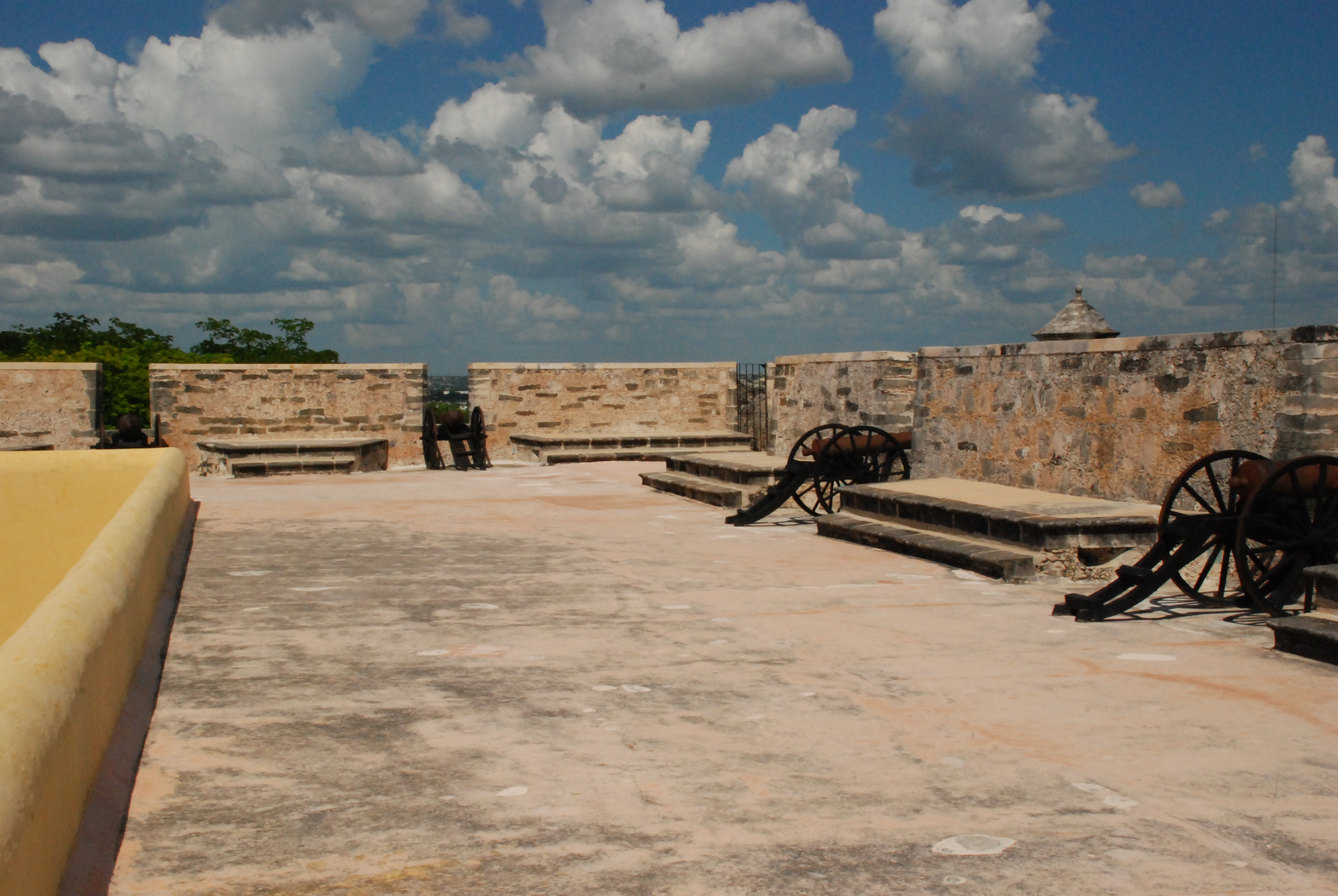
Its position is easy to understand once you stand outside. The rise gives the fort a commanding relationship with the coast and the approach to the city. Defensive architecture is about sightlines, controlled movement, and the ability to concentrate fire, not only about thick walls. The winding approach and entrance sequence slow movement. The ditch, bridge, gate, interior spaces, and elevated firing positions form a chain of decisions that makes the building legible even if you know little military history.
Look for how the fort turns arrival into a process. A visitor does not step directly from the road into a broad plaza. The route narrows, changes direction, and passes through controlled thresholds. That design would have made an assault more difficult and given defenders opportunities to observe and respond. The same features now shape the museum visit: you move from exterior ramparts to rooms, from open views to concentrated displays, and from the city’s maritime horizon to the deep history of the peninsula.
San Miguel should not be confused with the bastions inside Campeche’s historic centre or with Fuerte de San José el Alto. Those places belong to the same broad defensive story but are separate monuments with different locations and visitor experiences. The city walls and bastions are woven into an urban walk. San Miguel feels more detached, more elevated, and more like a self-contained military work. If you enjoy fortifications, make time for both kinds of site instead of treating one as a replacement for the other.
The fort was used and altered after the colonial period. In the twentieth century the building passed through other uses and then was restored for museum purposes. The museum’s present identity grew through later interventions, including work associated with INAH and an expanded archaeological collection. That layered history is worth remembering: the building is not frozen at one date, and the museum is not simply a military museum with a few Maya objects added as decoration.
The Museo de Arqueología Maya inside San Miguel
The museum’s principal strength is the way it brings together objects from several archaeological regions of Campeche. INAH describes collections that include funerary jade masks from Calakmul, ceramic figures from Jaina, and Maya stone sculpture. The cases are therefore not just a display of attractive objects. They let you compare materials, styles, social messages, and burial traditions across a state whose landscapes range from the Gulf coast to the forested interior.
Begin with geography. Before concentrating on a mask, vessel, or figure, identify where the object came from and how far that place is from Campeche City. Calakmul, in the southern rainforest, is not a quick extension of a city tour. Jaina lies off the northern coast and is associated with remarkable ceramic figures. Uxul and other sites add more depth to the regional picture. A map or introductory gallery helps you see that “Maya” does not describe one uniform place or a single visual style.
The museum’s displays are the reason to visit, but its public INAH photo record is not a substitute for seeing the objects in person. Follow the gallery labels for the current arrangement and do not assume that an object shown in an older online photograph is still displayed in the same case.
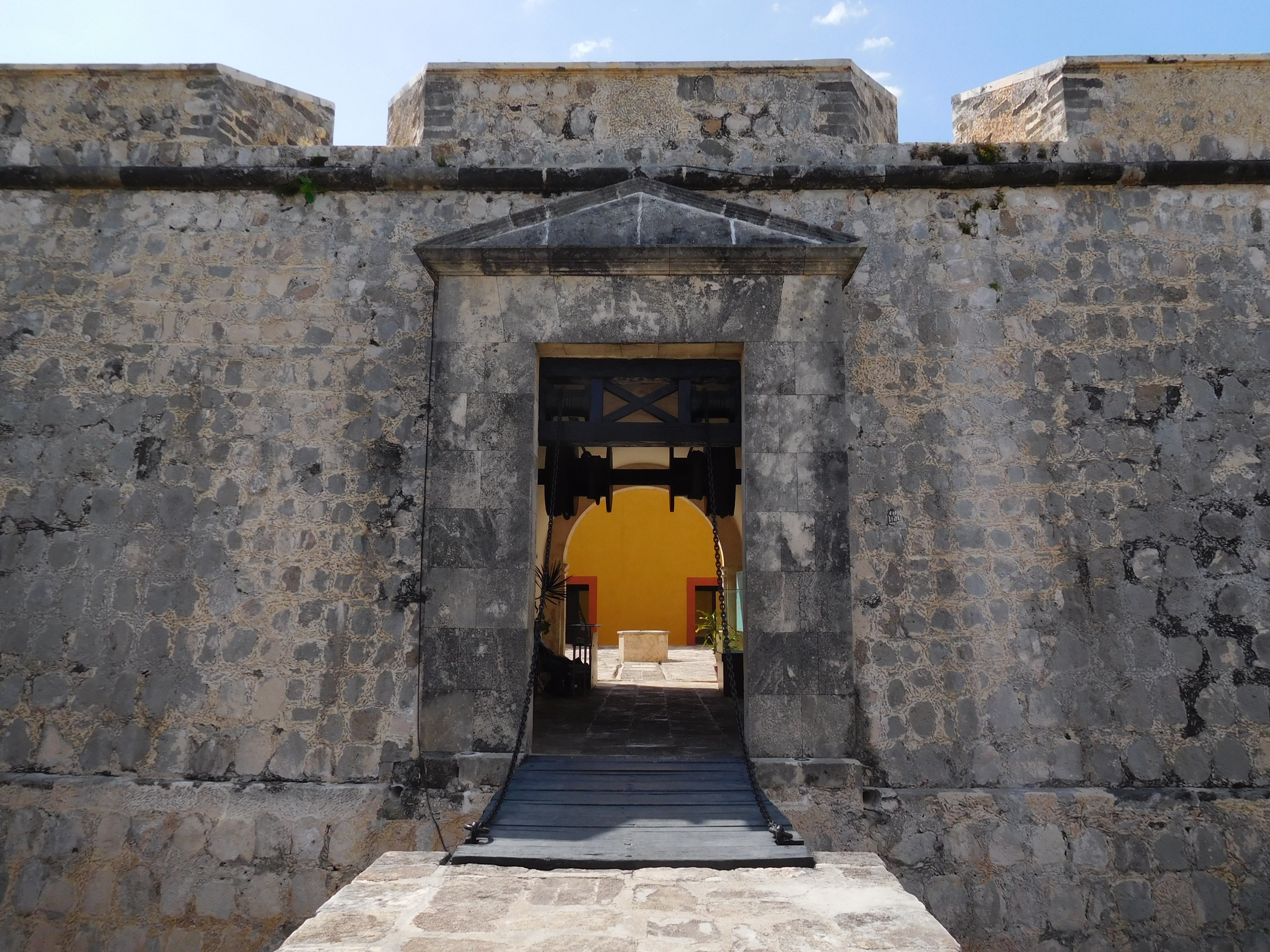 The entrance passage of Fuerte de San Miguel in Campeche
The Calakmul jade masks deserve time. Jade was not merely a decorative green stone. In elite funerary contexts, material, colour, craftsmanship, and placement communicated status and ideas about transformation, identity, and the afterlife. A mask can look calm and symmetrical in a case, but its original setting was part of a larger burial programme involving a ruler, a tomb, offerings, and political memory. The museum cannot recreate the entire tomb, yet it can show why these objects matter before you encounter Calakmul’s pyramids in the jungle.
Do not reduce a funerary mask to a portrait in the modern sense. Maya artists and patrons worked within religious and political systems in which faces, headdresses, eyes, mouths, and materials could carry layered meanings. Read the label, compare nearby examples, and notice differences in workmanship. If a display identifies a specific ruler, site, or period, treat that information as more reliable than a guide’s broad claim that every mask represents the same deity or person.
Jaina’s ceramic figures provide a different kind of encounter. They are often admired for their posture, clothing, gestures, and human detail. They can show how people of different roles were represented, including figures with elaborate dress or signs of status. Their small scale encourages close observation: hands, ornaments, facial expression, hair, and the relationship between a figure and its base. These are not generic dolls. They belong to funerary and social contexts that require careful interpretation.
 A Maya archaeological vessel from the Campeche region
Ceramics also explain daily and ceremonial life. A vessel’s shape can indicate how it was used, while painted scenes and inscriptions can refer to rulers, gods, feasting, or the act of presenting an object. Uxul material is particularly useful for thinking about relationships between sites. The political map of the Maya lowlands changed over time; sites were linked by conflict, marriage, trade, ritual, and shared artistic conventions. The museum lets you ask those questions without pretending that one case answers them all.
Stone sculpture shifts the scale again. Carved monuments can feel less intimate than jade or ceramics, but their size and public setting were part of their meaning. Look for traces of costume, posture, glyphs, and the way a figure occupies a block or panel. A photograph of a carved stone at an archaeological site may show weathering and landscape; a museum display lets you examine the object’s surface at close range. Both experiences are valuable and neither fully replaces the other.
The galleries also help correct a common travel mistake: treating Calakmul as the only Maya history in Campeche. Calakmul is extraordinary, but the state’s archaeological record includes different communities, periods, artistic traditions, and environmental settings. San Miguel is a compact orientation to that variety. If the collection leaves you wanting more, use that interest to choose a realistic next destination rather than trying to fit every southern site into one day.
GuideBaluarte de la Soledad & Museo de Arquitectura Maya: Visitor GuideA practical guide to Baluarte de Nuestra Señora de la Soledad and the Museo de Arquitectura Maya in Campeche’s walled centre, including its fortifications, Maya collections, access, timing, and how to combine the visit with a walk through the historic city.Explore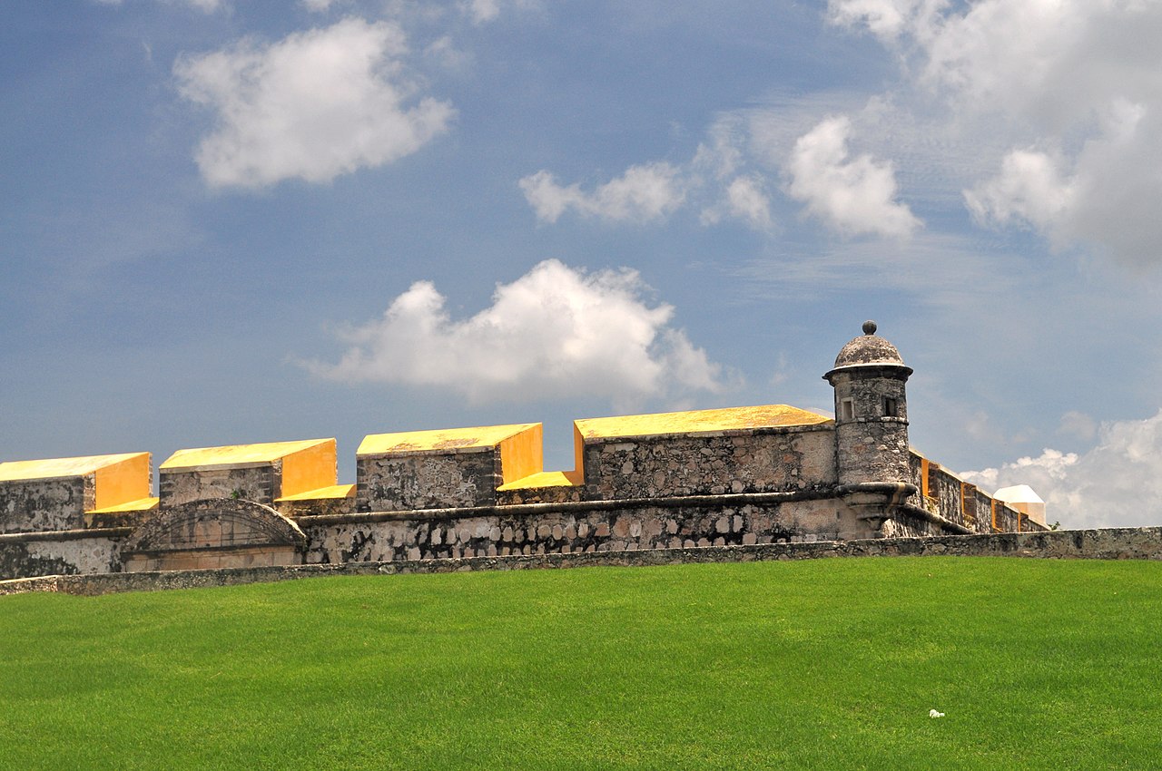
How to read the museum without rushing
A first pass should establish the museum’s map and timeline. On a second pass, select three objects: one from Calakmul, one ceramic figure or vessel, and one stone sculpture. Ask the same questions of each. Where did it come from? What material is it made from? Who could see it originally? Was it connected with a tomb, a palace, a ritual, or everyday use? What does the label say, and what are you inferring beyond the label?
This approach is better than trying to photograph every case. It also suits families. Children can look for animals, faces, unusual shapes, and repeating patterns while adults read the longer context. Turn the visit into a conversation about why an object was made and what happens when it is moved from an archaeological site into a museum. Keep voices low and follow the no-touch rule; the objects are not props for an interactive attraction.
Visitors with a strong interest in archaeology should leave room for uncertainty. Museum labels may identify a site and a date without settling every question about an object’s original use. Maya history has been reconstructed through archaeology, epigraphy, art history, and community knowledge, and interpretations develop as research continues. A confident guide who assigns one simple meaning to every symbol is less helpful than a label that distinguishes evidence from interpretation.
The collection also asks an ethical question about context. Archaeological objects have histories before and after excavation. The museum’s role is to conserve, study, and interpret them, while the visitor’s role is to approach them with respect rather than treating ancient remains as treasure detached from place. Do not touch display cases, lean on masonry, or use flash. If you want a deeper account of conservation and research, ask staff whether a current public programme or official virtual resource is available.
Pairing San Miguel with the walled city
The most natural companion to San Miguel is the historic centre. Inside the walls, you can see how the city’s defensive system met ordinary urban life: gates opened toward streets, bastions occupied corners, churches and civic buildings structured public space, and houses faced narrow routes built for a port city. A fort on a hill gives the military overview; the centre shows what was being protected.
Begin at a gate or central plaza, then walk at a pace that leaves time for one or two interiors. The exact order depends on opening days and your interests. The Baluarte de la Soledad and Museo de Arquitectura Maya offer a different, more urban museum experience, while the cathedral, public squares, and surviving wall sections help you read the city’s layout. Avoid cramming all of these into the same hot hour. Choose the fort early, rest, and return to the centre when the light and temperature are more forgiving.
 Puerta de Tierra and the fortifications of Campeche’s historic centre
The wall is not just a backdrop for the fort story. It defined movement, separated the defended city from its surroundings, and shaped the streets visitors enjoy today. From a wall walk or bastion, notice the contrast between tight colonial blocks and the open bay. At San Miguel, reverse that perspective: the city becomes part of a coastal defensive landscape rather than the whole scene.
A guided walking tour can be useful if you want the fortifications explained in sequence or if you prefer not to arrange transport between the centre and San Miguel. See current Campeche City walking and history options on GetYourGuide and compare available Campeche products on Viator. Confirm the meeting point, whether transportation is included, and whether the fort’s museum admission is separate. Do not assume that a listing’s mention of “fort” means a long museum visit; read the current itinerary.
GuideBastions of Campeche: San Carlos, San Francisco, San Pedro, Santa Rosa & SantiagoExploreA simple half-day plan
For a focused half-day, leave the historic centre after breakfast and arrive at San Miguel close to opening. Spend the first part of the visit outside, when the sun is gentler, then use the galleries for the middle of the morning. Take notes on two or three objects rather than trying to retain every name. Before leaving, look back toward the coast and identify how the hill controls the approach to Campeche.
Return to the centre for lunch and a rest during the strongest heat. In the afternoon, walk a short section of the walls or visit one city museum, then finish on the malecón as the light changes. The plan works because it separates the fort’s uphill exposure from the centre’s shaded streets. It also avoids pretending that San Miguel, Edzná, and the southern rainforest belong in a single casual morning.
If you have a full day, add the historic centre in more depth rather than adding a distant archaeological site by default. A day trip to Edzná is a separate outing with its own transport and heat considerations. Calakmul requires much more time and is normally planned with an overnight base in the south. San Miguel is a good primer for either destination, but it does not make those long drives shorter.
Travellers who are staying outside the centre can reverse the order. Go to the fort first, then continue toward the walled city or the malecón. Drivers should check parking and road conditions in advance. Taxi users should arrange the second leg before leaving the museum if they want a fixed plan. A flexible day is often more pleasant than a timetable with five exact stops, because museum entry, traffic, weather, and lunch rarely align perfectly.
Where to stay for the visit
Most visitors use San Francisco de Campeche as their base. Staying in or near the historic centre makes an evening walk, a morning market visit, and access to the city’s museums easier. Staying farther along the waterfront or outside the walls can provide more space or parking, but it usually means arranging transport for the fort and old town. Decide based on the shape of your whole trip, not on San Miguel alone.
For a first visit, compare the walkability of the historic centre with the convenience of a larger property outside it. Families may value parking, a pool, and a quieter room after a hot day. Couples who want to step out for an early stroll may prefer a central base. Budget travellers should check whether the quoted room rate includes the facilities they actually need, especially air conditioning and a reliable way to reach the fort.
Check current Campeche City stays on Booking.com · Compare Campeche hotels on Trip.com
Do not book a southern jungle lodge simply because the name Calakmul appears in a search result if your main plan is San Miguel. Xpujil and the Calakmul area are useful bases for the rainforest and ruins, but they are a substantial distance from Campeche City. Likewise, Ciudad del Carmen is a separate coastal base in the state and is not a practical overnight substitute for a city museum visit unless it already fits your route.
Who will enjoy the fort most?
San Miguel is especially good for travellers who like architecture, archaeology, museums, or places where different histories meet. It rewards people who read labels and notice construction details. It is also a strong stop for repeat visitors who have already walked the main streets and want to understand why Campeche’s World Heritage landscape includes more than colourful façades.
Families can enjoy it if adults set a manageable pace and explain the fort as a puzzle of gates, walls, views, and rooms. The museum is quieter and more concentrated than an outdoor ruin, which can be helpful in hot or rainy weather. However, young children may find long labels tiring, and the exposed approach is not ideal at the hottest time. Bring water and make the visit one part of a day, not an endurance test.
It may be less satisfying if you want a beach outing, a lively market, or a place to wander without a fixed route. The fort is a museum and monument, not a waterfront promenade. Visitors with very limited time should first decide whether they care more about Maya objects or about the walled centre. If the answer is the city streets, stay inside the walls. If the answer is archaeological context and defensive architecture, make the trip to San Miguel.
Common mistakes to avoid
The first mistake is confusing the fort with the museum alone. The collection is a major reason to visit, but the hill, approach, ditch, walls, and views are part of the experience. The second is treating the fort as a replacement for Calakmul. A mask in a case can prepare you for the rainforest site, but it cannot reproduce the scale, vegetation, distance, or atmosphere of Calakmul.
Another mistake is arriving on Monday without checking the schedule. The published INAH hours are Tuesday through Sunday, and institutional calendars can change. Check the official listing shortly before travelling. Do the same for admission prices and photography rules. Search snippets can preserve old rates long after a museum has updated them.
Do not plan to walk there in the same way you walk through Calle 59. The location on Avenida Escénica is part of the city, but the route is separated from the compact pedestrian centre by ordinary roads and open stretches. Use a taxi, car, or confirmed public-transport plan. If you walk, do so only with a realistic map, adequate water, and a clear understanding of the return route.
Finally, do not photograph people praying or turn a religious and archaeological site into a competition for the fastest checklist. The fort has a military past, but the museum holds human remains, funerary objects, and culturally important material. Move slowly, obey staff, and let the place remain more complicated than a pirate story or a collection of pretty stones.
Final recommendation
Visit Fuerte de San Miguel early, when the hill is more comfortable and the view helps you understand the building’s purpose. Give the museum enough time to connect Calakmul jade, Jaina ceramics, Uxul vessels, and Maya sculpture with the wider geography of Campeche. Then return to the walled centre and walk its streets with the fort’s elevated perspective in mind. That pairing turns San Miguel from an isolated attraction into one of the clearest ways to understand why Campeche is both a fortified Gulf port and a gateway to Maya history.