Campeche’s bastions are easiest to understand as parts of one defensive city, not as a checklist of seven unrelated buildings. The Spanish colonial port was enclosed by walls and protected by projecting strongpoints, gates, a moat, batteries, and two larger hilltop forts. Some of the bastions survive as substantial monuments. Others were altered, partly demolished, incorporated into later streets, or given a new cultural use. Together they explain why San Francisco de Campeche feels different from other colonial cities on the Yucatán Peninsula.
The most useful bastions to know are San Carlos, San Francisco, San Pedro, Santa Rosa, and Santiago. Baluarte de la Soledad belongs in the same conversation and is covered in a separate detailed guide, while San Juan and the former San José works help complete the defensive geography. This guide concentrates on how to see the named bastions in a sensible order, what each one contributes, and how to avoid expecting every site to offer the same kind of visit.
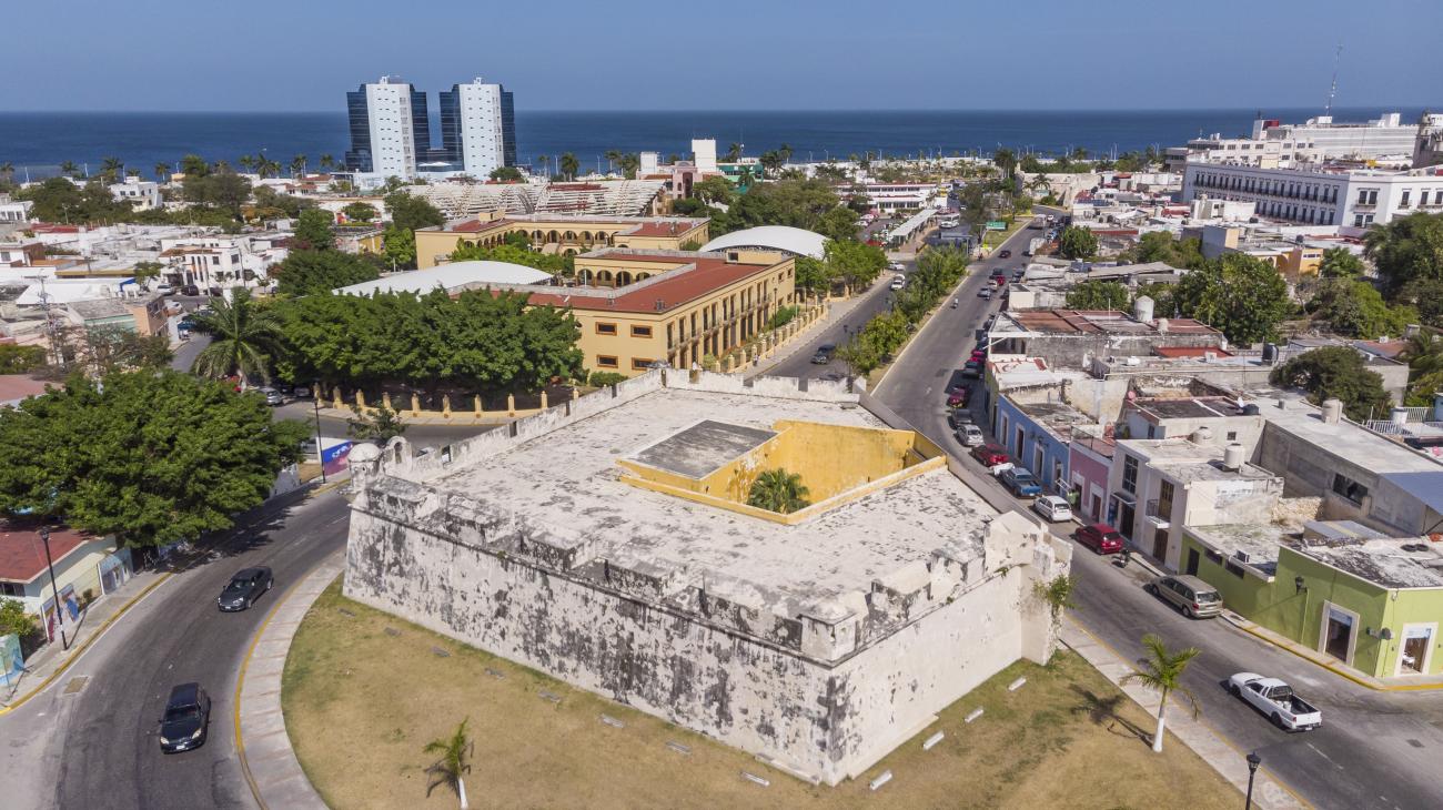 Aerial view of Baluarte Santa Rosa and Campeche’s Gulf-facing urban edge
Why Campeche has bastions
Campeche grew as a Gulf port in a region with a much older Maya history. Its harbour connected the colonial settlement with maritime commerce, timber, agricultural products, and routes across the Gulf and Caribbean. That economic role also made it a target. Privateers and pirates could approach by sea, while the city still needed to control roads and movement on the landward side.
The answer was not one castle placed outside town. Defence developed in stages. Walls enclosed the central settlement, and bastions projected from the wall line so defenders could watch and fire along the faces of the walls as well as toward the approaches. Gates controlled movement through the enclosure. Later works beyond the wall, including Fuerte de San Miguel and Fuerte de San José el Alto, strengthened the higher ground around the city.
A bastion is therefore not simply a small fort. It is a defensive angle integrated into a larger fortified perimeter. The projecting shape allowed defenders to cover areas that would have been difficult to protect from a flat wall. Rooms inside could serve as storage, shelter, or artillery positions. The exact military arrangement varied from site to site, but the basic principle was the same: protect the wall, the gate, and the people and goods inside the city.
The defensive system was built and modified over decades rather than completed in one perfect campaign. The names reflect saints and religious dedications common in the colonial period. The surviving structures also have different later histories. Some became museums or exhibition spaces. Some remained visible primarily as monuments. One, Santiago, was reconstructed and adapted as a botanical garden. This mixture is not a weakness; it is the reason a walk through the bastions reveals both military history and the changing life of the city.
INAH and Mexico’s World Heritage authorities describe the fortified historic town as a connected heritage ensemble. UNESCO inscription in 1999 applies to the historic town and its fortifications, not to one favourite viewpoint. When visiting, look beyond the masonry. The relationship between colourful houses, the grid of streets, the waterfront, gates, churches, and defensive structures is the important part.
The bastion circuit at a glance
The names can be confusing because maps and visitor information sometimes use baluarte, bastion, or a longer dedication. San Carlos is near the waterfront side of the historic centre. San Pedro, Santa Rosa, and Santiago are associated with the southern and eastern portions of the old enclosure. San Francisco and San Juan protected the landward gate area. San Carlos and San Francisco are not the same place, and neither should be confused with Fuerte de San Miguel, which stands outside the walled centre on higher ground.
A practical first visit usually combines the bastions with Puerta de Tierra, Puerta de Mar, Calle 59, the main square, and Baluarte de la Soledad. You can walk between several of the central sites, but the defensive line is not a single uninterrupted elevated promenade. Some sections are set beside ordinary roads, some have limited public access, and some are better appreciated from outside.
Allow at least half a day if you want to enter the museums and pause for photographs. A quick exterior circuit can fit into a shorter historic-centre walk, but it will not give you time to understand the differences between the buildings. Early morning is the most comfortable period for a longer route. The stone and pavement reflect heat later in the day, and shade is uneven.
For a guided interpretation of the walls, gates, museums, and bastions, compare current Campeche City walking tours on GetYourGuide with Campeche City tours on Viator. Product routes and availability change, so check the actual meeting point and inclusions rather than assuming every listing visits all five bastions.
Baluarte de San Carlos
San Carlos is one of the most recognisable bastions on the waterfront side of the historic centre. INAH identifies it as part of Campeche’s defensive system and notes that it later became a troop barracks. Its position helps explain the city’s concern with both the harbour and the urban approaches: the bastion was not an isolated lookout, but one corner of a fortified enclosure.
The name refers to Saint Charles, and historical accounts generally place San Carlos among the early bastions of the city. The structure has the heavy, practical character expected of a defensive work: thick masonry, elevated parapets, and a projecting form that makes more sense when read with the adjoining wall. It is not the same kind of museum visit as Baluarte de la Soledad or Fuerte de San Miguel. Access arrangements can change, and a traveller may experience San Carlos mainly as an exterior monument or as part of a broader fortifications route.
Stand far enough away to see the bastion’s relationship with the surrounding streets. Close-up photographs flatten the angles and can make it look like an ordinary wall. From the public space around it, notice where the wall line turns and how the structure occupies the corner. Then look toward the waterfront and inland streets. The city’s defensive logic was based on controlling movement, not on creating a scenic viewpoint.
San Carlos is useful early in a route because it introduces the idea of a bastion as a corner of the enclosure. Pair it with the nearby central streets and the seaward side of the historic centre, then continue toward the other surviving strongpoints rather than spending the whole morning looking for a single entrance that may not be open.
The exact museum use, opening arrangement, and event schedule should be confirmed locally if your plan depends on going inside. Historic properties can close a room for conservation or host a temporary cultural programme. Do not infer access from an old blog photograph or a timetable copied from a previous year.
 Baluarte de San Carlos in Campeche’s fortified historic town
Baluarte de San Francisco
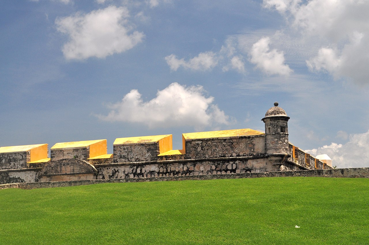
San Francisco was the fifth bastion built, and INAH describes its construction as taking place between 1686 and 1690. Its architecture is similar to Baluarte de la Soledad, although the two structures have different positions and later histories. San Francisco helped protect the landward side of the city and is closely associated with the Puerta de Tierra area.
One reason San Francisco matters is that it shows how the fortifications were affected by modern urban change. INAH records that in 1899 the New Urban Tram Company of Campeche requested permission to demolish part of the bastion to create a road connection between the city centre and the Santa Ana neighbourhood. The surviving structure is therefore not a pristine object untouched by the modern city. It is a preserved fragment that also records the pressure to open, connect, and modernise Campeche.
The bastion’s location makes it an easy addition to a landward route. Begin at Puerta de Tierra, inspect the gate and moat, and then look for the defensive relationship with San Francisco and nearby San Juan. The route is more informative if you imagine defenders moving along the wall rather than treating each building as a separate photo stop. Where the wall is visible, follow its direction with your eyes. Where a street has replaced or cut through the historic line, use the surviving bastion as the anchor for the missing section.
San Francisco can be appreciated from outside even when interior access is limited. Look at the irregular geometry, the thickness of the walls, and the way the parapet sits above the city street. The most useful photograph includes the bastion and enough of its urban setting to show that it protects a gate corridor rather than standing in open countryside.
If you are travelling with children, this is a good place to explain the basic function of a bastion without turning the visit into a long lecture. Ask them to identify the wall, the corner, the gate direction, and the road approaching the old city. Keep them away from edges, uneven masonry, and any areas marked for conservation.
GuideBaluarte de la Soledad & Museo de Arquitectura Maya: Visitor GuideA practical guide to Baluarte de Nuestra Señora de la Soledad and the Museo de Arquitectura Maya in Campeche’s walled centre, including its fortifications, Maya collections, access, timing, and how to combine the visit with a walk through the historic city.ExploreBaluarte de San Pedro
San Pedro occupies another section of the historic defensive line and is often mentioned in descriptions of Campeche’s seven surviving bastions. Later uses have shaped how visitors encounter it. Historical and tourism accounts associate the structure with an Inquisition-era prison, although a traveller should distinguish the building’s later reputation from the original military purpose.
That layering makes San Pedro different from a bastion that is primarily presented as a museum or garden. The structure carries several stories at once: the defence of a port, colonial religious and judicial authority, and the reuse of military architecture as the city changed. Read the site first as part of the wall, then as a building with later associations. Doing so avoids reducing Campeche’s history to a single pirate narrative.
San Pedro is particularly worthwhile on a walk between the landward gate and the central streets. It helps demonstrate that the old enclosure was a living urban system. Bastions were close to churches, homes, markets, and administrative buildings. Their walls were not remote from ordinary life. They influenced how people entered the city, where streets could pass, and which spaces remained controlled.
Because the accessible portion and interpretation can vary, do not promise yourself a particular interior collection unless you have confirmed it. If the building is closed, the exterior still contributes to the circuit. Look for the projecting mass and consider its position in relation to the adjoining wall. Then continue toward Santa Rosa or Santiago, depending on the route and the day’s heat.
Photography should be respectful around any active cultural or religious use. A bastion may look empty in a photograph while still being part of a neighbourhood with residents and working streets. Avoid blocking entrances, climbing on the walls, or treating public space as a private photo set.
GuideBaluarte de la Soledad & Museo de Arquitectura Maya: Visitor GuideA practical guide to Baluarte de Nuestra Señora de la Soledad and the Museo de Arquitectura Maya in Campeche’s walled centre, including its fortifications, Maya collections, access, timing, and how to combine the visit with a walk through the historic city.ExploreBaluarte de Santa Rosa
Santa Rosa was the first bastion to be completed, according to INAH’s Campeche information. It was built where a small fortress called Santo Cristo de San Román had stood. The structure is made with local saskab stone bonded with a mixture that included seashells, a detail that connects the monument to the materials and building knowledge of the peninsula rather than to an abstract European fortification diagram.
The bastion’s name and location also show how religious and military meanings overlapped in the colonial city. A former small fortress associated with San Román gave way to a major defensive work dedicated to Santa Rosa. That does not mean the earlier history disappeared. It became part of the accumulated meaning of the place.
INAH describes Santa Rosa as having been abandoned at the end of the nineteenth century before one of its rooms opened to the public in 1995 to display a model of the walled enclosure and portraits connected with pirates who attacked the city during the viceregal period. This is a helpful kind of interpretation because the model allows you to see the whole defensive outline after looking at only one corner in the street.
If the room is open, use the model as a map rather than as a decorative object. Find the gates, identify the other bastions, and note how the wall enclosed the central town. Then compare that model with what you can see outside. The surviving urban landscape is incomplete, but the relationship between the pieces becomes clearer once you have a bird’s-eye representation.
Baluarte Santa Rosa, one of Campeche’s surviving historic bastions
Santa Rosa is also a useful reminder that image filenames and online listings are not substitutes for local interpretation. The INAH image above shows the bastion in its Campeche urban setting; the visible structure is a defensive corner with the city and Gulf beyond, not a hilltop Maya ruin or a generic colonial wall. In person, look for the angles and parapet before focusing on surface colour, since paint and weathering can change.
Plan for direct sun around the open perimeter. A hat, water, breathable clothing, and shoes with a secure sole are more useful than heavy sightseeing equipment. The stone can be uneven, and the route between bastions includes normal city pavements rather than a managed park trail.
GuideBaluarte de la Soledad & Museo de Arquitectura Maya: Visitor GuideA practical guide to Baluarte de Nuestra Señora de la Soledad and the Museo de Arquitectura Maya in Campeche’s walled centre, including its fortifications, Maya collections, access, timing, and how to combine the visit with a walk through the historic city.ExploreBaluarte de Santiago
Santiago is one of the most accessible bastions for travellers who want a clearly defined cultural destination rather than only an exterior wall. The reconstructed bastion contains the Xmuch’haltún Botanical Garden, which presents plants from the Yucatán Peninsula in a setting connected to the old fortification. The garden changes the pace of the visit: instead of concentrating only on artillery, parapets, and colonial conflict, you can see how regional vegetation and urban heritage occupy the same enclosure.
The reconstruction is important to understand. Santiago should not be presented as an untouched seventeenth-century interior. Its value comes from the way a defensive footprint was restored and adapted for public interpretation. The garden does not recreate military life in every detail, but it makes the bastion legible to visitors who may otherwise find a mass of masonry difficult to read.
Give yourself time to notice the contrast between the planted interior and the exposed defensive perimeter. Plants soften the space, while the wall’s thickness and elevated edge still communicate its original purpose. This is a good stop for families because the garden provides something concrete to observe between historical explanations. It also gives photographers a different composition from the bare stone and street scenes at the other bastions.
Santiago works well as a middle or late stop on a walking circuit. Visit the more enclosed museums while you still have attention for labels, then use the garden as a less concentrated pause. Alternatively, start here if you want to orient yourself before walking toward the gates. Check the current public opening arrangement before setting out; botanical garden access is subject to local management and may differ from the schedule of nearby monuments.
Do not confuse the bastion’s garden with the larger landscape of Calakmul or the Calakmul Biosphere Reserve. It is an urban botanical collection inside a reconstructed historic defence. Its plants are relevant to the regional environment, but the experience is compact and city-based.
GuideBaluarte de la Soledad & Museo de Arquitectura Maya: Visitor GuideA practical guide to Baluarte de Nuestra Señora de la Soledad and the Museo de Arquitectura Maya in Campeche’s walled centre, including its fortifications, Maya collections, access, timing, and how to combine the visit with a walk through the historic city.ExploreBaluarte de la Soledad and the missing pieces of the circuit
Baluarte de Nuestra Señora de la Soledad is often the best-known bastion because it contains the Museo de Arquitectura Maya. It is also the largest of the city’s bastions and stands near the old seaward entrance. The museum displays architectural elements and sculpture from Maya sites in Campeche State, including material associated with regional traditions such as Chenes, Río Bec, Puuc, and Petén Norte.
The museum makes Soledad a particularly strong companion to the other bastions. At San Carlos, San Francisco, San Pedro, Santa Rosa, and Santiago, you are reading military architecture in the city. At Soledad, you can examine Maya architectural fragments at close range inside another historic structure. The two histories should not be collapsed into one story, but they can be understood together in the same afternoon.
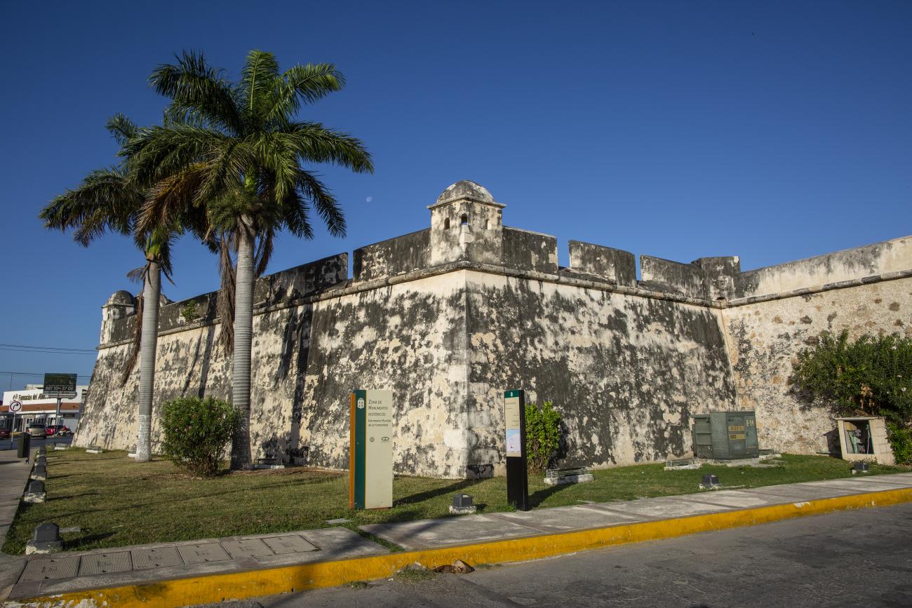 Baluarte San Juan, a remaining section of Campeche’s fortified urban perimeter
San Juan is not one of the five bastions in this guide’s title, but it helps complete the landward picture. INAH describes it as the fourth bastion, completed in 1698 to protect and defend Puerta de Tierra. It suffered damage during a period when it was used as a residence, and portions of the walls on both sides remain. The photograph shows how a surviving defensive mass can sit beside ordinary urban traffic and landscaping.
San José is another name that requires care. The former San José works in the wall system are not equivalent to Fuerte de San José el Alto, and descriptions of the city sometimes use “San José” without making the distinction clear. Fuerte de San José el Alto is a separate fort outside the central wall and has its own museum history. If you want to visit it, confirm the full Spanish name and current access locally so you do not arrive at the wrong site.
The same caution applies to San Miguel. Fuerte de San Miguel is not a bastion embedded in the central wall. It is a larger fort on higher ground and now houses the Museo de Arqueología Maya. Its collection and elevated setting make it one of the most worthwhile additions to a bastions day, but it should be treated as a separate short taxi ride or vehicle stop rather than as the next corner in a continuous walk.
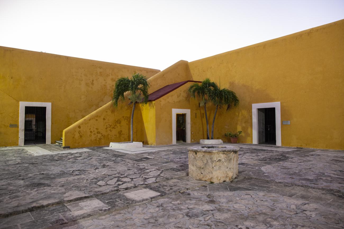 Courtyard of Fuerte de San Miguel, home of Campeche’s Maya archaeology museum
A sensible one-day route
Start in the historic centre before the strongest heat. If staying nearby, walk to the main square and use the early quiet to orient yourself. From there, choose either a seaward or landward beginning. The seaward option leads naturally toward Baluarte de la Soledad, Puerta de Mar, and San Carlos before turning through central streets. The landward option begins at Puerta de Tierra and connects San Francisco and San Juan with the southern and eastern portions of the old wall.
A useful sequence is Puerta de Tierra, San Francisco, San Juan, San Pedro, Santa Rosa, Santiago, the central plaza, Baluarte de la Soledad, and then the waterfront. This is not a promise that every interior will be open in that order. It is a geographic framework. Use the open street sections to connect the places and adjust according to current access, shade, and your interest in museums.
After lunch or a rest, continue to Fuerte de San Miguel if the museum is open and you still have energy. The fort is worth separating from the bastion circuit because its hilltop position changes the view. From there, the city’s fortified centre reads as a broader urban landscape rather than a sequence of close walls.
A shorter version is better than a rushed full circuit. Choose Puerta de Tierra, San Francisco or San Juan, Santiago, Soledad, and the waterfront. You will see the defensive logic, one adapted cultural space, one major museum, and both gates without pretending that every surviving fragment requires a long stop.
If the evening presentation at Puerta de Tierra is running during your visit, return after a rest rather than trying to combine it with the hottest part of the afternoon. Current performance days, language, ticketing, and start time need local confirmation because schedules change. The show is a theatrical interpretation of Campeche’s past, not a substitute for daylight inspection of the masonry.
Walking, taxis, and heat
The historic centre is compact, but compact does not mean cool or completely easy underfoot. The distances between sites are manageable for many visitors, yet the route includes sun, stone, traffic crossings, and stretches without obvious shade. Begin early, carry water, and leave room for a café or indoor museum break. A route that looks short on a map can feel longer after several hours in Gulf heat.
Use a taxi for Fuerte de San Miguel, for luggage, or when the heat turns a pleasant walk into an endurance exercise. Ask for the full name of the destination and keep the return plan simple. For the central bastions, walking is usually more informative because the gaps between them are part of the heritage landscape.
The best shoes are stable and breathable, with enough grip for old paving and steps. Flip-flops can be uncomfortable on a long route. A light layer can help in strongly air-conditioned museums, while sun protection matters outside. Cash is useful for small purchases and local transport, but do not assume every attraction has the same payment arrangements; verify admission and ticket methods when you arrive.
Accessibility varies because these are historic defensive buildings, not modern museums designed on a single level. Expect steps, thresholds, narrow passages, uneven stone, and changing access to upper areas. If you use a wheelchair or have limited mobility, ask staff which portions are step-free and consider a route focused on exteriors, gates, the central plaza, and museums with the clearest current access. A taxi can reduce the distance between the walled centre and the hilltop forts, but it cannot remove every historic threshold.
Where to stay for a bastions visit
The most convenient base is in or near Campeche’s historic centre, especially if the main goal is to walk before breakfast and return for a midday break. A stay outside the centre can work if you have a car or prefer a quieter setting, but you will spend more time arranging short transfers. For a first visit, prioritise a location that makes the main square, Calle 59, the gates, and the waterfront reachable without a complicated taxi plan.
If the bastions are one part of a larger state itinerary, Campeche City also works as a base for Edzná and for a transition toward the coast. It is not a practical day-trip base for Calakmul; the jungle drive is long enough that a southern overnight base is more sensible. Keep those geographies separate when booking.
Check current Campeche City hotel availability on Booking.com · Compare Campeche City hotels on Trip.com
There is no advantage in naming a property simply to fill a list. Compare the actual map location, cancellation terms, air conditioning, parking if needed, and recent comments about noise and stairs. In the walled centre, an attractive old building may have steps or compact rooms; outside the centre, a modern property may be easier for luggage and vehicles. Choose for the route you genuinely plan to walk.
Guided tour or independent visit?
An independent visit gives you control over pace and lets you spend longer at the bastion or museum that interests you. It is also the best approach when several interiors have uncertain schedules. Read the INAH descriptions before setting out, use the city’s signs, and connect each surviving structure to the gates and wall line.
A guided city tour can help if military vocabulary, colonial chronology, and later urban changes feel difficult to connect. When comparing listings, look for a route that explicitly mentions the walled city, gates, bastions, or museums. Do not assume a “Campeche highlights” product includes every bastion. See current GetYourGuide options for Campeche City and compare Viator’s Campeche city-tour inventory.
A tour is most useful when it adds interpretation rather than merely driving past the monuments. Ask whether the route includes walking, which museums are included, whether admission is separate, and where the meeting point is. If you want to visit Fuerte de San Miguel as well, confirm that it is part of the itinerary instead of assuming “fortifications” means both the central bastions and the hilltop fort.
Independent travellers can also combine a short self-guided walk with a separate museum visit. This avoids paying for a long city tour when your interest is specifically the architecture, while still providing a guide for a wider day trip if desired. The right choice depends on whether you want historical explanation, logistical convenience, or time to photograph and observe without a group schedule.
Photography and respectful visiting
The best photographs show the bastions in context. Include a section of wall, a street, a gate, or the surrounding roofs so viewers can understand the monument’s place in Campeche. A tight image of a parapet can look like any fort in the region. Wide views are especially useful at San Carlos and Santa Rosa, while lower street-level views can show how San Francisco and San Juan meet modern traffic.
Light is harsh in the middle of the day. Morning and late afternoon bring more texture to masonry, but the exact best time depends on the side of the structure you are visiting. Do not enter closed rooms, climb over barriers, or stand in traffic for a shot. Ask before photographing museum objects, temporary displays, staff, or local residents.
The bastions are protected heritage structures. Touching or leaning on fragile masonry adds wear, and climbing can damage edges that appear solid. Keep food and drinks away from museum objects, follow signs, and leave plants undisturbed in Santiago’s garden. These are small actions, but they matter in buildings exposed to heat, rain, salt air, and heavy visitor use.
Common mistakes to avoid
The first mistake is treating the bastions as interchangeable. San Carlos, San Francisco, San Pedro, Santa Rosa, Santiago, Soledad, and San Juan have different positions and later uses. Visit fewer sites with attention rather than racing to photograph every name.
The second is confusing the central bastions with the hilltop forts. Fuerte de San Miguel and Fuerte de San José el Alto belong to the wider defence system, but they are not simply the next two bastions on the wall. Plan transport and time for them separately.
The third is relying on an old timetable. Museum access, temporary exhibitions, botanical garden opening, and the Puerta de Tierra light show can change. Verify locally, especially around holidays and when a visit depends on an evening performance.
The fourth is underestimating the climate. A historic-centre map can make the circuit look effortless, but Campeche’s heat and reflected pavement are real constraints. Carry water and plan a break.
The fifth is expecting the fortifications to look like a complete unbroken wall. Parts were altered or removed as the city modernised. The missing sections are part of the history. Use the surviving bastions, gates, and museum models to reconstruct the larger enclosure in your mind.
The sixth is reducing the story to pirates alone. Attacks help explain the defensive investment, but the bastions also reveal colonial administration, port commerce, urban planning, materials, later military use, conservation, and the present-day life of a historic city. The most rewarding visit leaves room for all of those layers.
Is the bastions circuit worth it?
Yes, if you enjoy architecture, history, museums, or walking through a city whose original defensive plan remains legible. The circuit is less satisfying if you want every monument to have a large interior exhibition, a panoramic viewpoint, or a fixed visitor route. Some bastions are best understood from outside, while others reward an indoor visit or a garden stop.
The strongest approach is to select a core group: Puerta de Tierra and San Francisco or San Juan for the landward defence; Santa Rosa and Santiago for the surviving bastion fabric and adapted public use; Soledad for the Maya architecture museum; and San Carlos or the waterfront for the seaward context. Add Fuerte de San Miguel when you want a broader view and more archaeology.
Before leaving Campeche, walk a short section of the old perimeter again without rushing. Notice how a colourful residential street, a gate, a bastion, and the Gulf-facing city can occupy one connected landscape. That relationship is the real attraction. The individual structures give you the vocabulary, but the fortified town gives the visit its meaning.
For a first visit, stay near the historic centre, begin the bastion walk early, verify which interiors are open, and keep the hilltop forts as a separate decision. That plan gives you enough time to see the major surviving defences without turning Campeche’s best historical experience into a hot race between walls.