Campeche’s historic centre is the part of San Francisco de Campeche that most rewards a slow arrival. It is not a single monument with a gate and a ticket booth. It is a living district of low colonial façades, working homes, churches, plazas, museums, narrow streets, and a defensive wall that still gives the city its shape. The centre is compact enough to explore on foot, but it has enough layers for a half-day visit to feel rushed and a three-day stay to feel unhurried.
The city’s formal UNESCO name is the Historic Fortified Town of Campeche. UNESCO inscribed it in 1999 because the harbour town preserves both a Baroque colonial urban plan and an extensive Caribbean military system. The historic core is laid out on a grid, while bastions, gates, curtain walls, and the outlying forts explain why the settlement was so important to Spain and so vulnerable to attacks by sea. The result is a place where everyday errands happen inside an unusually legible piece of urban history.
This guide focuses on the walled centre itself: what to see, how the streets fit together, how to pace a visit, where to sleep without inventing a hotel shortlist, and how to combine the old town with the forts, museums, food, and waterfront. It also explains what the centre is not. Campeche’s historic district is not Calakmul, not Edzná, and not a substitute for the state’s jungle archaeology. Those places need separate transport and more time. Here, the pleasure is the relationship between buildings and streets.
What the historic centre feels like
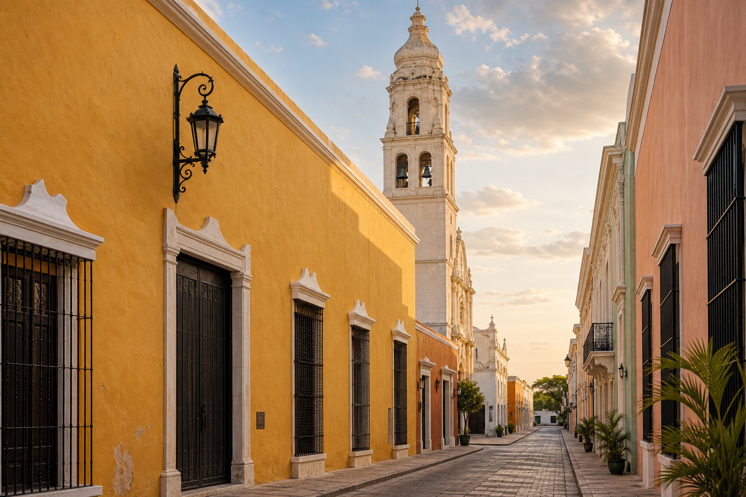
The first impression is usually colour and proportion. Many façades are painted in strong but controlled shades, and most buildings remain low enough that the streets retain a human scale. Doorways open directly onto sidewalks. Windows are often protected by bars or shutters. Cornices, pilasters, carved details, and painted walls reward looking upward, but the district is not an empty architectural set. People live, work, worship, shop, eat, and move through it every day.
The walled area is easy to understand once you identify three anchors: Plaza de la Independencia in the middle, Puerta de Mar on the side facing the bay, and Puerta de Tierra on the inland side. Calle 59 runs between the two gates and is the most obvious east-west orientation line for a first visit. Around it, the grid breaks into quieter streets where the best discoveries are often a balcony, an old doorway, a small chapel, or a façade that has been maintained without being turned into a major attraction.
The city can feel hot even when the walking distance looks modest. Gulf humidity makes the stone and paving radiate heat in the middle of the day. A route that appears short on a map may include pauses for photographs, museum visits, shade, and water. Build the day around two walking periods rather than trying to cover everything continuously from late morning through the afternoon.
 A colourful colonial building in Campeche’s historic centre
Why Campeche is a UNESCO historic town
UNESCO recognition is useful here because it describes the whole urban system rather than a single pretty street. The official Historic Fortified Town of Campeche entry identifies the city as a model of a Baroque colonial harbour town with a checkerboard plan and defensive walls influenced by Caribbean military architecture. The fortifications were built in response to the risks attached to Campeche’s port economy. Ships carried valuable regional products, and the Gulf route connected the town to wider Atlantic trade.
The wall should not be understood only as a pirate backdrop. It controlled access, separated the defended town from its surroundings, gave soldiers protected circulation routes, and tied the city’s military needs to its street plan. Bastions projected outward so defenders could cover the faces of the walls. Gates were points of movement and control. Outlying forts on higher ground extended the defensive picture beyond the centre.
The UNESCO designation also protects the relationship between the fortifications and the colonial town. It is possible to see the wall, step through a gate, cross a plaza, and understand how the pieces work together without travelling between disconnected archaeological fragments. The conservation is not perfectly uniform, and not every street feels polished, but that is part of the district’s character. Restoration and daily use sit beside weathered paint, modern utility infrastructure, and ordinary commerce.
For a deeper architectural explanation, compare this walk with the site’s INAH description of the fortified historic city. INAH is especially helpful for understanding the defensive system as a historic monument rather than as a collection of photo stops.
GuideCamino Real de Campeche: The Historic Route from Mérida to CampecheExplore
Start at Plaza de la Independencia
Plaza de la Independencia is the natural starting point because it gives you a calm centre before you begin following walls and gates. It is also the place where the city’s civic, religious, and commercial histories overlap. The cathedral faces the square, and other historic buildings form the edges. Sit for a few minutes before taking photographs. You will read the surrounding streets more clearly once you have seen how the plaza organizes them.
The square has changed over time. Like many colonial plazas, it was not frozen in its earliest form. Its name, furniture, landscaping, and relationship to public life have been altered by different administrations and periods of modernization. That does not make it less historic; it shows how the city has repeatedly negotiated the meaning of its centre. Today, the plaza functions as a gathering point as much as a monument.
 Plaza de la Independencia in Campeche’s historic centre
Look for the way the cathedral’s vertical towers contrast with the low façades around the square. Then walk a short distance down adjoining streets and return from a different direction. The view changes with each block because the grid reveals façades obliquely rather than delivering one continuous boulevard. Early morning is good for seeing the architecture without heavy foot traffic. Evening brings more local movement and softer light, but it is not the best time to inspect small architectural details.
Do not treat the plaza as a quick photograph between activities. It is the place to reset your map, check the heat, and decide whether you are ready for a museum or better suited to a shaded street and a long drink. If you are travelling with children or anyone who tires easily, use it as the meeting point for the day.
Campeche Cathedral
The cathedral, formally dedicated to Our Lady of the Immaculate Conception, is one of the centre’s clearest landmarks. Its pale façade and twin towers make it easy to recognize from nearby streets, while the interior gives the plaza a continuing religious function rather than turning it into a purely secular heritage space. Dress respectfully, keep voices low, and remember that access may change around services or religious events.
The building has its own history of alterations and conservation. INAH’s broader Campeche material notes that the cathedral’s fabric and crypts have been part of the city’s historical investigations. You do not need to turn a visit into a technical study, but it is worth looking at the difference between the formal front, side walls, paving, and the surrounding houses. The cathedral is not isolated from the town; its scale sets the tone for the square.
 The twin towers of Campeche Cathedral beside the historic-centre streets
If you want context before exploring alone, a verified option is the Campeche Historic City Center Guided Walking Tour on GetYourGuide. It is listed as a walking experience focused on the centre, museums, churches, and city history. For another marketplace, Viator’s Campeche walking-tour inventory is the sensible comparison point. Check the current meeting point, language, inclusions, and schedule before booking because activity details can change.
GuideBaluarte de la Soledad & Museo de Arquitectura Maya: Visitor GuideA practical guide to Baluarte de Nuestra Señora de la Soledad and the Museo de Arquitectura Maya in Campeche’s walled centre, including its fortifications, Maya collections, access, timing, and how to combine the visit with a walk through the historic city.Explore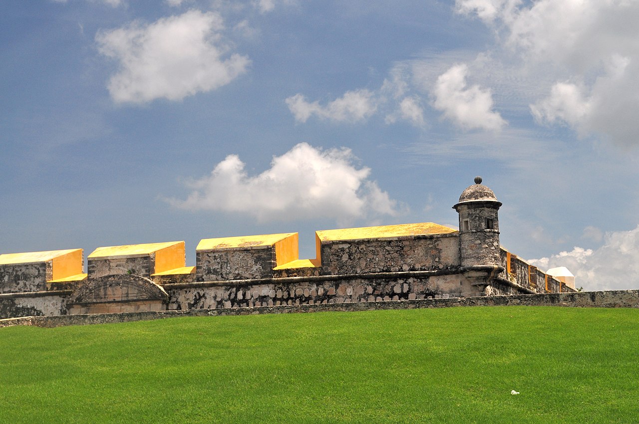
Puerta de Mar and the bay side
Puerta de Mar was the connection between the defended town and the sea. Its position between the bastions of San Carlos and La Soledad makes the geography easy to understand: this was not simply a decorative arch but a controlled threshold between the harbour and the urban interior. The gate has been altered and restored through the city’s later history. INAH records that the original gate was destroyed in the nineteenth century and that the wall and gate were restored in the twentieth century.
Start from the landward side and look through the opening toward the bay. Then turn around and observe how the street pulls you back into the centre. This short exercise explains the old town better than a list of dates. Goods, sailors, officials, workers, and residents all crossed a point where the city could monitor movement.
Puerta de Mar is also a useful transition to the malecón. The waterfront promenade is outside the intimate grid of the centre and has a more open, linear feel. You can combine the gate with a sunset walk, but do not confuse the malecón with the historic centre. They complement each other: one is a fortified colonial town, the other is a broad Gulf-facing public corridor.
From the gate, give yourself time to explore the blocks around La Soledad and San Carlos rather than immediately following the most obvious tourist street. Some of the strongest impressions come from transitions: a wall meeting a house, an old façade beside a modern sign, or a church street opening toward the bay. The historic centre works best when you allow these small changes to accumulate.
Calle 59 without reducing the centre to one street
Calle 59 is the easiest route for a first-time visitor. It links Puerta de Mar and Puerta de Tierra and contains a concentration of places to pause, eat, and orient yourself. It is also the street most likely to be busy, especially during popular evening periods. Walk it once to understand the layout, then move onto parallel streets for a quieter view of the district.
The mistake is to regard Calle 59 as the entire historic centre. It is a spine, not a complete itinerary. The streets crossing it lead toward churches, residential façades, plazas, and bastions. Some blocks are more commercial and some are more residential. The contrast helps you see the difference between a heritage route designed for visitors and a functioning centre used by residents.
Use Calle 59 for practical breaks and orientation. If you are hungry, this is where you can compare current menus and choose according to what is open rather than relying on an invented or outdated recommendation. Campeche cooking deserves a dedicated visit, particularly dishes based on local seafood and the state’s distinctive sauces, but the historic centre is not a reason to assume every attractive façade is a restaurant. Look at the menu, prices, and seating before committing.
For a more detailed street-level route, the existing Calle 59 guide can be read alongside this article. The important planning point is simple: walk Calle 59, but do not spend the whole day walking only Calle 59.
Puerta de Tierra and the inland edge
Puerta de Tierra is the most complete surviving original access point in the defensive system and one of the centre’s most legible military monuments. INAH describes it as a gate built between 1725 and 1727, between the San Francisco and San Juan bastions. It includes a masonry parapet, a surrounding moat, vaulted side spaces, and defensive details that show how an entry could be both monumental and practical.
Approach from outside first if you can. From that angle, the moat and layered masonry make more sense. Then pass through and look back toward the entrance. The gate was built to manage threat and movement, not to provide a dramatic arrival for modern cameras. The surviving defensive features are valuable precisely because they show the logic of the system.
Conditions inside the gate and on connected wall sections can vary with conservation work, events, weather, and operating decisions. Do not rely on an old blog for current opening hours or a promised light-and-sound schedule. Check the local tourism or monument information close to your visit. If a section is closed, the exterior, moat, and surrounding bastions still make the walk worthwhile.
Puerta de Tierra is a good end point for a morning route that began at the plaza, or a good starting point for an afternoon route that finishes toward the bay. The best choice depends on the sun and your energy. In hotter months, the inland side can feel exposed. Bring water and do not plan to stand on every wall section during the brightest part of the day.
The bastions: how to choose what to see
Campeche’s bastions are often described as a checklist, but they are better understood as different corners of one defence. The surviving structures include San Carlos, La Soledad, San Pedro, San Francisco, San Juan, Santa Rosa, Santiago, and the remains or altered history of other defensive points. Some hold museums or cultural uses; others are best appreciated from the street or wall line. The exact public access and exhibits can change, so confirm locally rather than treating a printed list as a guarantee.
Baluarte de la Soledad
La Soledad stands close to Plaza de la Independencia and Puerta de Mar. It is particularly useful for visitors who want to connect the city’s colonial defence with Maya archaeology. The Museo de Arquitectura Maya is associated with the historic centre and interprets architectural elements from the wider state. Check the current museum status, ticketing, and display arrangement before building your entire day around an interior visit.
Even when you cannot enter, the bastion’s position explains the defensive geometry. Stand near the junction with the wall and look toward the gate, the plaza, and the bay. Its projecting form was intended to cover approaches that a straight wall could not see. This is why bastions should be visited as part of a route rather than as isolated buildings.
Baluarte de San Carlos
San Carlos sits near the sea side and helps complete the picture around Puerta de Mar. Its scale and position show how the city defended a valuable maritime entrance. Depending on current cultural programming, it may have a museum or interpretive use. Verify what is open when you arrive, and allow more time if an exhibit is operating rather than simply taking an exterior photograph.
Baluarte de San Francisco and Baluarte de San Juan
These bastions flank Puerta de Tierra. They make the inland gate feel like a defended complex rather than a free-standing arch. Walk slowly along the exterior walls and note the changes in height, angles, and sight lines. If you visit at a quiet hour, you can usually spend more time understanding the relationship between the structures than you can during a busy evening event.
Baluarte de Santa Rosa, San Pedro, and Santiago
The eastern and southern portions of the wall are useful for visitors who want to escape the busiest central streets. Their interest lies partly in the walk between them. The city’s defensive perimeter becomes a way to read the outer edge of the old town, with modern streets and neighbourhoods beyond. A short route here can be more rewarding than trying to enter every bastion.
Do not assume that a bastion name means a museum is open every day or that the building’s current function is the same as its colonial one. Heritage sites remain under maintenance, and institutions sometimes change. Treat the wall as the reliable experience and individual interiors as bonuses to confirm locally.
Fuerte de San Miguel: outside the walled centre, essential for context
Fuerte de San Miguel is not inside the historic centre, but it belongs in a complete visit because it shows how Campeche defended itself beyond the urban wall. The fort sits on higher ground and houses the Museo de Arqueología Maya. Its collections connect the capital with archaeological sites across Campeche, including the state’s major Maya centres.
Plan it as a separate stop rather than squeezing it between two quick walks. You need transport from the centre, and the hilltop setting changes the experience from street-level architecture to a strategic view. A taxi, local transport, or a planned guided visit can work; ask about the current return arrangements before leaving the centre. If you are driving, confirm parking and follow local signs rather than assuming the museum’s access is identical to an online map pin.
The fort is particularly useful before a trip to Edzná or Calakmul because it gives you a state-wide archaeological frame. It is not a replacement for either site. Edzná is a major archaeological zone outside the city, while Calakmul requires a long jungle approach and an overnight strategy for most travellers. Read the separate Edzná guide or Calakmul guide when planning those excursions.
A city walking tour may include historical context but not every fort entrance. If you want a structured experience that combines the centre with a fort, compare the current Campeche activity listings on GetYourGuide and Campeche tours on Viator. Read the actual itinerary carefully. A destination page contains many different products, and not every listing starts in the historic centre.
Churches and everyday heritage
The cathedral is the most obvious church in the centre, but it is not the only one worth noticing. San Román, Guadalupe, San Francisco, and other churches connect the old town to neighbourhood histories and religious traditions. Some are closer to the wall and some lie outside the most photographed central blocks. If a church is open, enter as a visitor to a living religious space: avoid flash photography where prohibited, do not block worshippers, and check whether an event is in progress.
The churches also help you avoid a common mistake: reading Campeche only through Spanish military history. The city’s heritage includes Maya and Afro-descendant histories, trade, religious practice, local families, port labour, food, and later political change. A façade is one piece of the story. The continued use of these buildings is another.
The Iglesia de San Román and the devotion associated with the Black Christ are especially important to Campeche’s local culture, but the church’s significance is not a reason to arrive during a service and treat it like an attraction. If your visit coincides with a religious festival, expect changes in traffic, access, and crowd levels. Festival dates should be checked through current local announcements rather than assumed from an old calendar.
A practical one-day walking route
A manageable one-day plan begins early at Plaza de la Independencia. Spend time with the cathedral and the square, then take the surrounding streets toward Puerta de Mar. From there, walk the nearby wall and bastions, using any open museum as a deliberate stop rather than trying to visit everything. Continue along Calle 59 for a meal or break, then take parallel streets toward Puerta de Tierra.
At Puerta de Tierra, inspect the gate and moat from both sides. If your energy and the heat allow it, continue toward quieter bastions on the eastern edge. Otherwise return to the centre for a long afternoon pause. Later, walk toward the malecón for open air and sunset. This sequence works because it alternates enclosed streets, defensive structures, food, and the bay rather than asking you to walk continuously in full sun.
A second version reverses the direction. Start at Puerta de Tierra, walk through Calle 59, pause at the plaza, and finish at Puerta de Mar and the waterfront. This is useful if your lodging is closer to the inland edge or if you want the bay to be the final view. Neither route is objectively better. Choose based on where you start and when you expect the sun to be strongest.
The route is not a race. A first visit should leave room for wrong turns. The grid is forgiving, and a quiet side street can be more memorable than a second museum. Carry a phone map, but use it for orientation rather than navigating every step. Look for shade before you need it, and keep some cash for small purchases or contingencies because payment options vary among independent businesses.
How many days should you spend
One full day is enough to see the principal streets, plaza, cathedral exterior or interior if open, both gates, several bastions, and the evening waterfront. It is a good introduction if Campeche is one stop on a longer route between Mérida and the southern state.
Two nights are better for most independent travellers. You can split the walking into morning and evening periods, visit a fort or museum without sacrificing the entire centre, and eat at a more relaxed pace. You also gain flexibility if rain interrupts a route or a monument is closed when you first pass.
Three nights make sense if the city is your base for Edzná, a coastal visit, or a longer cultural itinerary. Do not use extra nights as an excuse to make a rushed day trip to Calakmul and return exhausted. Calakmul is far enough away that it deserves its own transport calculation, an early start, and often an overnight base near Xpujil. The historic centre is a good place to recover from, or prepare for, a longer state journey.
Where to stay around the centre
Staying inside or immediately beside the walled centre is the easiest choice if your priority is walking. You can return to your room during the hottest hours, step out for evening photographs, and avoid arranging transport for every meal. The trade-off is that historic buildings may have stairs, compact rooms, limited vehicle access, or less predictable parking. Ask directly about air conditioning, luggage access, noise, stairs, and secure parking if those details matter to you.
The area just outside the walls can be more practical for drivers. You may find easier vehicle access and a quieter room while remaining close enough to walk or take a short taxi ride. The best base depends on whether you value immediate street atmosphere or straightforward arrival. Do not choose solely from a photograph of a colourful façade.
For current availability, compare Campeche City stays on Booking.com with Campeche hotels on Trip.com. Search the exact dates and inspect the map. A listing described as “central” may be outside the walls, and a low price may exclude the features you need. If you book a converted historic property, confirm whether the room is reached by stairs and whether late arrival is practical.
Arrival, parking, and getting around
Campeche is reachable by long-distance bus, train connections, road, and flights into the city’s airport. The historic centre itself is compact, but the transport hub is not necessarily beside the plaza. If you arrive with luggage, take a registered taxi or arrange a clearly identified transfer rather than beginning a hot walk with bags. For bus logistics, the existing ADO Campeche guide covers the station-focused side of the arrival.
A rental car is useful for Edzná, the coast, and longer routes through the state, but it is not necessary for the centre. Narrow streets, one-way sections, pedestrian activity, and limited parking make walking simpler once you are near the walls. If your lodging offers parking, ask whether the space is on-site or nearby and whether access is restricted during evening events.
If you drive to the centre, park legally and remove luggage and electronics from view. Do not block a doorway, wall access, or a narrow lane merely because a map suggests a short stop. The old street grid was not designed for modern traffic. In the evening, use a registered taxi if you have been drinking or if you are unfamiliar with the route outside the busy centre.
Cycling can work on calmer streets and the waterfront, but cobbles, traffic, heat, and pedestrians require attention. The city is not a place to assume that a bicycle automatically makes every route faster. Walking is usually the most informative way to see the centre because it lets you stop at façades and change direction easily.
Heat, rain, and accessibility
Plan around the weather rather than treating it as a minor inconvenience. Early mornings are usually the most comfortable for long wall walks and detailed architectural viewing. Late afternoon and evening are useful for colour, street life, and the malecón. The middle of the day is better for a shaded meal, a museum, or a hotel break.
Rain can arrive quickly, especially in wetter months. Stone paving becomes slippery, and outdoor wall sections may be uncomfortable or temporarily restricted. A lightweight rain layer is more useful than an umbrella in crowded streets. Protect cameras and phones, and do not assume a forecast showing a shower means the rest of the day will be dry.
The centre is walkable, but walkable does not mean fully step-free. Cobblestones, uneven paving, curbs, narrow thresholds, stairs, and elevated wall routes create real barriers. Travellers using wheelchairs or with limited mobility should ask each museum and lodging about entrances and accessible toilets directly. A private walking tour may be adaptable, but confirm the route rather than relying on a generic “historic centre” label.
For families, the centre works well when the route is broken into short sections. Make the plaza, a gate, a shaded snack break, and the waterfront separate goals. Children often respond better to the wall as a maze and lookout than to a long explanation of colonial engineering. Keep them away from exposed edges and military masonry where barriers are limited.
Food and breaks in the old town
Campeche’s centre is a practical place to eat because you can choose among current options while walking. Look for busy places with a menu that is clear about what is served, and ask which dishes are available that day. Local seafood, pan de cazón, pastries, fruit drinks, and regional preparations can all be part of a visit, but avoid assuming that a dish is available simply because it appears in an old guide.
Markets and everyday food spaces may operate on schedules that differ from evening restaurants. A morning market visit pairs naturally with an early walking route, while Calle 59 and the streets around the plaza are convenient when you want to eat without leaving the centre. Carry water and treat a café or restaurant break as part of the route, not as time lost.
Heat changes appetite and timing. A large meal in the brightest part of the afternoon may make a wall walk unpleasant. Eat earlier or later, and use the middle of the day to rest. If you have allergies or dietary restrictions, communicate them in Spanish where possible and confirm ingredients rather than relying on a generic menu description.
GuideCampeche Old Town Guide: Streets, Plazas, Food, and Photo SpotsBeyond the famous walls and bastions, discover Campeche's authentic daily rhythm. Explore colorful streets, hidden plazas, genuine food markets, and photogenic corners that locals use, not just tourists.Explore
What to photograph, and what to leave alone
The best photographs are often taken from a few steps back. Include the street, paving, shade, and neighbouring façades rather than cropping every image into a single doorway. From the wall, frame the contrast between the defensive stone and the low coloured town. At the plaza, compare the cathedral towers with the surrounding roofline. At Puerta de Mar, use the opening to show the direction of the bay.
Avoid climbing on restricted masonry, entering closed spaces, or using a drone without understanding Mexican aviation and heritage rules. Some churches and museums limit photography. Residents may not want their open doorway or family gathering photographed. A respectful travel photograph is usually better than one taken from a prohibited position.
Sun direction matters. A gate that looks flat in harsh midday light may show much more texture in the morning or late afternoon. If you are staying two nights, revisit a favourite street rather than searching for a completely new one. The centre’s character changes with light, open doors, and the movement of people.
Is the historic centre touristy?
It is the most visited part of the capital, so you will encounter tours, restaurants, souvenir shops, and people taking photographs. It is not, however, a sealed theme park. The district continues to function as a city centre, and the balance between visitor activity and ordinary life is part of what makes it interesting.
Crowds are usually concentrated around the plaza, Calle 59, the gates, and scheduled events. Move one or two blocks away when you want quieter streets. Visit monuments early if you want to read details without waiting. In the evening, expect more people along popular dining streets and the malecón.
Standard urban precautions still apply. Keep your phone secure in busy areas, use official transport, and do not leave valuables in a parked car. The historic centre is generally straightforward to explore, but comfort and awareness matter more than dramatic safety claims.
A two-day centre-focused plan
On day one, begin at Plaza de la Independencia and spend the morning with the cathedral, surrounding façades, and the streets leading to Puerta de Mar. Visit an open bastion or museum, eat in or near the centre, and rest during the heat. Return in late afternoon for Puerta de Tierra, Calle 59, and a walk toward the malecón.
On day two, go beyond the central checklist. Visit Fuerte de San Miguel if current museum information and transport suit you. Return for a slower neighbourhood walk, a market or food stop, and any interiors you missed. Use the evening for the wall line or waterfront rather than repeating the same central photographs.
This plan gives the city room to be more than a UNESCO label. It also protects you from a common travel mistake: trying to combine the plaza, every bastion, two forts, a long meal, and a distant archaeological site into one overheated day.
Common mistakes to avoid
The first mistake is planning around exact opening hours copied from an old article. Museums, bastions, churches, and performances can change their schedules. Verify locally close to the visit.
The second is treating every surviving wall section as equally accessible. Some portions are public routes, some have institutional uses, and some may be closed for maintenance or events. Enjoy the exterior geometry when access changes.
The third is confusing the city’s forts with Maya ruins. Fuerte de San Miguel is a colonial military building with an archaeological museum. Edzná and Calakmul are pre-Hispanic archaeological sites outside the centre. They belong to the same state itinerary but not the same walking route.
The fourth is underestimating heat. A compact map does not equal a cool walk. Start early, pause often, and use the evening for the most open-air sections.
The fifth is staying only on Calle 59. Walk it, then turn away from it. The centre’s quieter streets and less famous façades are where the living town becomes visible.
Final recommendation
Give Campeche’s historic centre at least one full day, and two nights if the city is more than a transit stop. Begin at Plaza de la Independencia, understand the relationship between cathedral, grid, gates, and walls, then let the route widen toward the bastions, Fuerte de San Miguel, and the malecón. Keep the schedule flexible enough for heat, rain, a closed museum, and an unplanned side street. Campeche is most convincing when you stop trying to finish a checklist and allow the fortified town to work as a town.