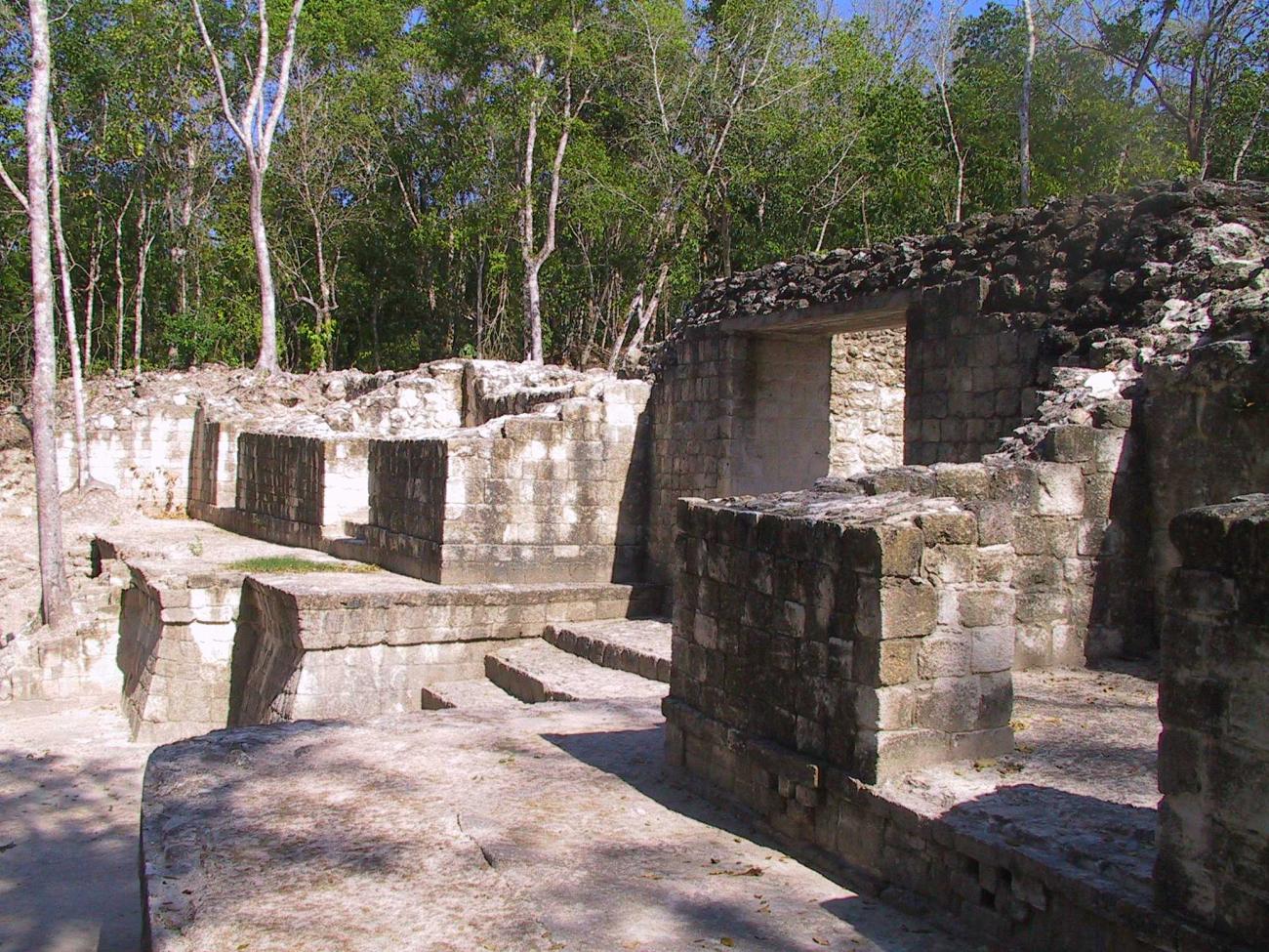
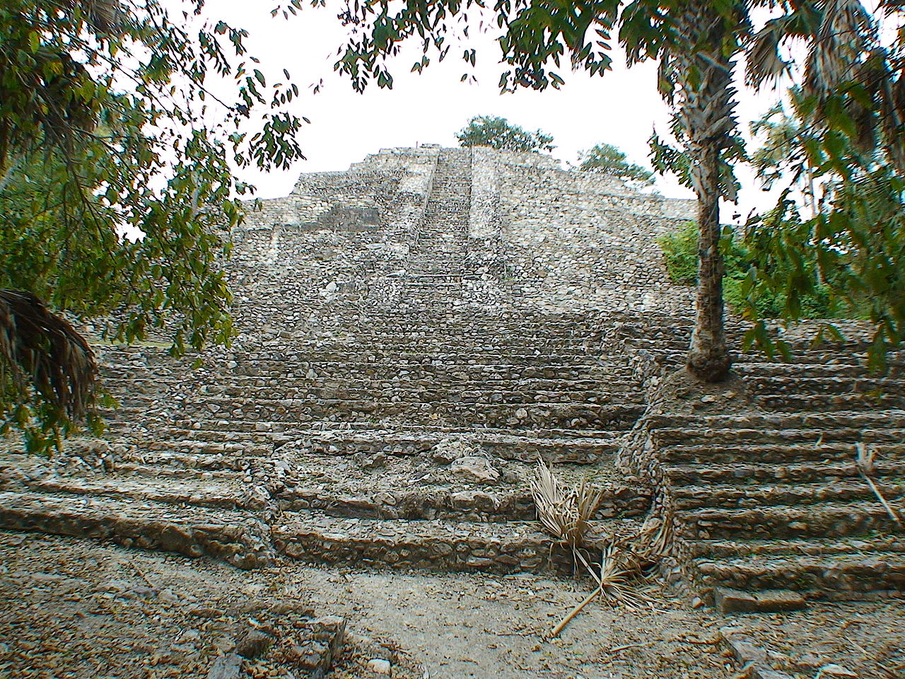
El Tigre is one of the most historically significant and least visited archaeological zones in Campeche State. The ruins sit on low hills beside the Río Candelaria in the municipality of Candelaria, in the state's southwest, and archaeologists identify them with Itzamkanac — the Chontal Maya capital that dominated trade between the Petén and the Gulf coast, and the place where Hernán Cortés ordered the execution of the last Mexica ruler, Cuauhtémoc, in February 1525. Despite that weight of history, you can arrive on most days and walk the plazas alone.
The contrast between importance and obscurity is the whole story of a visit here. El Tigre was occupied for some two thousand years, from the Middle Preclassic period (around 600 BC) until shortly after the Spanish conquest, longer than almost any other Maya city in the region. Its ceremonial heart holds large pyramidal platforms, a long palace range, carved stone masks under protective shelters, and a rare circular temple that ties the city to the Kukulcán cult of the Postclassic world. Yet the site sees a tiny fraction of the visitors who crowd Calakmul or even Edzná, and the surrounding villages live at a pace that has little to do with tourism.
This guide covers what the site actually contains, how its story connects to the conquest of Mexico, the practical details of getting there by road, boat, or train, and how to fold El Tigre into a wider Campeche itinerary. Distances and opening details below come from INAH, the federal institute that manages the zone; anything less certain is flagged so you can verify locally before committing a long drive.
Why El Tigre Matters: The Search for Itzamkanac
The modern name is a placeholder. El Tigre simply borrows the name of the ejido — the communal farming settlement — where the ruins stand. The city that stood here appears in Spanish colonial documents under a different name: Itzamkanac. INAH states plainly that diverse authors have identified the archaeological zone with that historical city, and the match matters because Itzamkanac was not a provincial backwater. It was the capital of Acalán, the province of the Chontal Maya — also called the Putún — who settled along the Río Candelaria and controlled one of the great trade corridors of the ancient Maya world.
The name Acalán translates as "place of canoes," which tells you how the city worked. The Río Candelaria runs north from the interior toward the Laguna de Términos and the Gulf of Mexico, and Itzamkanac sat on a navigable stretch of it, a river port linking the Guatemala highlands and Petén lowlands with the Campeche coast. Goods, ideas, and political influence moved through here in both directions. Colonial-era sources describe Itzamkanac as a port of great importance on the natural route between the Petén and the Campechana coast, and the archaeological record backs them up: the site spreads over roughly five square kilometers of low hills, with six separate architectural groups and evidence of contact reaching as far as central Mexico.
Identification is more than academic curiosity here, because Itzamkanac appears in one of the most famous episodes of the Spanish conquest. When Cortés marched from Mexico City toward Honduras in 1524–25, his route passed through Acalán, and it was at Itzamkanac that he had Cuauhtémoc — the emperor who had defended Tenochtitlan — put to death. If the identification is right, and INAH treats it as well supported, then one of the defining events of the conquest happened beside these quiet mounds. Few archaeological zones anywhere in Mexico carry that kind of documented historical weight, and almost none carry it with so few visitors around.
The Site Today: What You Actually See
Manage expectations before you set out. El Tigre is not a restored showpiece like Edzná or Chicanná. INAH describes a ceremonial center of four large structures and six smaller ones arranged around two plazas, with thirteen altars and three plain stelae, plus outlying groups across the five-square-kilometer site. Consolidation work has focused on the core, so what stands visible today is a sequence of big grass-covered platforms with exposed stairways, partially rebuilt walls of rough quarry stone, and a handful of protected sculptures rather than tall restored temples.
 Wide view over the excavated plaza at El Tigre (Itzamkanac), Campeche, with a tiered pyramid platform, a sheltered excavation, and palm trees under an overcast sky
The largest building, known as Estructura I or Edificio 1, closes the main plaza on its south side. It rises from a pyramidal base more than twenty meters high, and from the top the site opens up: the second plaza, the tree cover of the surrounding hills, and on clear days a hint of the Río Candelaria beyond the vegetation. Estructura II closes the plaza to the east and Estructura III to the west, where together with Estructura IV it frames the second plaza.
 Partially restored range building with several stairways on a grassy plaza at El Tigre (Itzamkanac), Campeche
Visitors who know the region will recognize the architectural vocabulary — broad platform terraces, balustraded stairways, range-type buildings — assembled without one single dominant regional style. INAH notes that the central area shows no defined architectural school, mixing traits the institute classifies as Petén-style, Río Bec-style, and late-period construction. That mixed character is itself part of the site's story: cities on trade routes tend to borrow from everywhere, and Itzamkanac's position between the Petén and the Gulf made it exactly that kind of crossroads.
Climbing is straightforward: stairways are stepped but steep, surfaces are uneven, and there is little shade on top of the platforms. Go early in the morning, carry water, and take the panoramic view from Estructura I slowly — it is the best vantage point for understanding how the plazas relate to the river landscape that made the city wealthy.
The Mascarones: Stucco Masks and the Preclassic Legacy
The site's most distinctive artworks are its mascarones — sculpted mask panels that once decorated temple façades — and they connect El Tigre to some of the oldest building traditions in the Maya lowlands. INAH notes that one of the plazas is framed by pyramidal platforms carrying anthropomorphic masks from the Preclassic period, making them well over a thousand years old. Similar façade programs at sites such as Kohunlich in Quintana Roo or Cerros in Belize date to the same era, when Maya architects sheathed early pyramids in enormous stucco faces of sun gods and rulers.
What you see today are carved stone cores with weathered modeling, several of them protected by simple shelters to slow erosion. The best-preserved panel shows a central figure flanked by rounded mask faces with ear ornaments, the features softened by centuries of rain but still clearly readable as a designed façade rather than random ornament. Restoration work led by INAH Campeche in recent years has focused exactly on these four modeled-stucco masks: conservators cleaned biological growth of insects and microorganisms from the surfaces and stabilized the fragile stucco.
 Weathered carved stone mask panels with ear ornaments under a protective shelter at El Tigre (Itzamkanac), Campeche
The archaeology behind these masks is unusually well documented because INAH's project director, Ernesto Vargas Pacheco, has discussed it publicly during the recent consolidation campaigns. His team found that some modeled-stucco pieces were first dedicated to a solar deity and later covered over by anthropomorphic masks representing deified ancestors — a layering that let each new ruler claim descent from divine forebears. Elsewhere on the site, two human figures rendered in modeled stucco may portray a king and queen of the city; both still carry traces of red, cream, and black pigment, and both were deliberately covered — not smashed — when later construction phases buried them. Vargas Pacheco reads the whole ceremonial core as a built cosmology: Estructura II as a sacred mountain, the source of life and goods; four great temples dividing the world into quarters, possibly one per ruling lineage; the group oriented astronomically toward the east. Whether or not you travel with that interpretation in mind, it explains why the site feels planned rather than accumulated — the plazas were designed as a single statement about how the world worked.
The Circular Temple: Kukulcán and the Postclassic City
In 2023 INAH announced a discovery at El Tigre that changed how the site's final centuries are understood: a circular two-level structure explored during Promeza improvement works, dating to the Early Postclassic period between roughly 1000 and 1200 AD. Circular temples of this type are associated with Ehécatl-Quetzalcóatl, the wind god, whose Maya counterpart was Kukulcán — the feathered serpent whose cult radiated out from Chichén Itzá across Yucatán. The building would originally have been crowned by a flat-roofed temple, and comparable circular basements survive at Edzná, Becán, Uxmal, and Chichén Itzá itself.
Why does a feathered-serpent temple matter at a river port three hundred kilometers from Chichén Itzá? Because it confirms what the colonial documents say: Itzamkanac stayed connected to wider Mesoamerica long after the Classic-period collapse emptied other southern cities. INAH links the structure's timing to an era of intense contact with central Mexico, Oaxaca, and the Gulf coast — precisely the regions from which the Quetzalcóatl cult traveled. A colonial-era document known as the Paxbolón Maldonado Papers, written by the Chontal lord Pablo Paxbolón in 1575–76, describes the city's principal temple as housing shrines to the four principal Postclassic deities, one of them Kukulcán. Archaeology and document now agree with unusual precision.
The same improvement campaign made the site far easier to visit than it used to be. Promeza works added about 1,530 meters of interpretive trails and renewed 49 information panels, and a visitor center was under construction at last report. Trails now lead you through the core groups in a readable sequence instead of leaving you to guess across open grass. Treat the completion status of visitor facilities as something to check locally — rural Campeche projects move slowly — but the path network itself is finished and signed.
Cortés, Cuauhtémoc, and the End of Acalán
No visit to El Tigre makes sense without the conquest story, because the site is one of very few Maya cities that appear by name in the eyewitness accounts of the fall of Mexico. In late 1524 Hernán Cortés marched from Tenochtitlan toward Honduras to deal with a rival Spanish expedition, a brutal overland trek through Tabasco and Acalán that his soldiers recorded in detail. He brought high-value prisoners with him, above all Cuauhtémoc, the young tlatoani who had surrendered Tenochtitlan in 1521, along with Tetlepanquetzal, ruler of Tlacopan.
At Itzamkanac in February 1525, Cortés accused Cuauhtémoc of plotting against the expedition and had him hanged, together with Tetlepanquetzal and another noble. The traditional date, February 28, comes from the conquest chronicles. The accounts disagree about guilt: Cortés himself claimed a informer revealed a conspiracy; Bernal Díaz del Castillo, who marched with the expedition and knew Cuauhtémoc personally, called the executions unjust and without evidence, and recorded the emperor's final words to Cortés — that he was being killed unjustly after having trusted himself to Cortés in his own city of Tenochtitlan. Modern historians broadly treat the killing as the removal of a dangerous hostage once the march grew hard, and Mexico commemorated five hundred years since the death in 2025.
Itzamkanac itself survived the conquerors by a generation. The city remained the seat of the Acalán province under its own Chontal lords — Pablo Paxbolón's papers describe its temples mid-century — until around 1557, when Franciscan friars relocated the population to the coast near Tixchel. That forced resettlement ended roughly two thousand years of continuous occupation, one of the longest sequences anywhere in the Maya area. Numbers recorded from a soldier of the expedition suggest the scale: the city reportedly held some fifteen thousand houses, which would imply a population in the tens of thousands, with more than a thousand structures scattered across the river hills and canoe traffic linking it to markets as distant as Tikal and Calakmul. Walking the quiet central plazas today, that metropolis takes imagination — but the platforms that remain are the visible skeleton of it.
Planning Your Visit: Hours, Tickets, and Rules
The practical framework comes from INAH and is refreshingly simple. The zone opens every day of the week from 8:00 to 17:00, with last access at 16:45. Foreign visitors pay 145 pesos; Mexican nationals and foreign residents pay 80 pesos. Sundays are free for Mexican citizens and residents, which matters for timing because it is the one day you might share the site. Entry is free for children under thirteen, students and teachers with valid credentials, and seniors. INAH also lists a fee for professional cameras — if you carry anything beyond a phone or basic camera, ask at the information module rather than assuming.
One rule surprises people: INAH caps the zone at a maximum of ten visitors inside simultaneously. In practice you will rarely encounter the limit, since ten simultaneous visitors would already make this the busiest day in recent memory, but it tells you how small the operation is. Services at the gate extend to parking, an information module, and restrooms — nothing more. There is no ticket office beyond the caretaker's desk, no café, no shaded picnic area, and no site museum yet.
Plan around that minimalism. Bring more water than seems reasonable — the plazas hold heat through the afternoon and shade is patchy — along with insect repellent, closed shoes for rough stairways, and cash in small bills, because card payments are not part of the setup. The visit itself takes between forty-five minutes and two hours depending on your interest in the masks and how much of the trail network you walk. If you have read up on Itzamkanac beforehand or hire a local guide if one is around (verify locally), add time at the sheltered mascarones; they repay attention.
Getting There: Road, River, and Rail
El Tigre sits roughly fifty kilometers from the town of Candelaria, and the drive is half the experience: flat farmland gives way to scattered villages named after Mexican states, and the final stretch runs on narrow rural pavement where you may share the lane with horses and motorcycles. INAH's own routing describes it precisely: from Candelaria follow the road toward the villages of Estado de México and Monclova, and between those two settlements take the signed 9.3-kilometer deviation that leads directly to the archaeological zone. Coming from the other direction — the Villahermosa–Escárcega highway corridor — the turnoff stands near the village of Nuevo Coahuila, following the Monclova branch road to the site.
A rental car is the practical choice for most travelers and makes it easy to continue toward Escárcega or the Río Bec corridor afterward. Distances here are long, fuel stations thin out fast once you leave the towns, and mobile signal fades in stretches, so fill the tank before leaving Candelaria or Escárcega. Rural signage has improved under the Promeza works but remains limited at village junctions; a downloaded offline map takes the stress out of the last few kilometers. If you are driving without your own vehicle, taxis and colectivos serve the villages out of Candelaria, but there is no fixed tourist service to the ruins — negotiate a round-trip fare and a pickup time locally (verify locally).
The alternative arrival is the reason many travelers put Candelaria on their map at all: the river. INAH describes access by boat from the town of Candelaria itself, running the Río Candelaria down to the site the way canoes did when this was the port of Acalán. Boat trips are arranged informally on the riverbank rather than through a ticket office (verify locally), and water levels vary by season, so treat the lancha option as an adventure that needs a local fixer rather than a scheduled excursion. On paper it is the most atmospheric approach to any ruin in Campeche State.
Rail travelers now have a third route. The Tren Maya passes through Candelaria as a halt on its Palenque–Escárcega section, and INAH explicitly promotes El Tigre as reachable via that stop. From the halt, the town center and its market sit within walking distance, and ground transport to the ruins can be arranged there. Train frequencies and stopping patterns change as the network matures, so check current timetables close to travel rather than planning around an old schedule. For context on the wider line, see the state-level guide to Tren Maya stations in Campeche.
If all of this sounds like more logistics than you want to absorb, guided options exist — though none currently focus on El Tigre itself. Compare Campeche-based tours and activities on GetYourGuide · see current Viator listings for the region; products concentrate on Edzná, Calakmul, and city tours, and an independent visit remains the only realistic way to reach this particular site for now.
Artifacts from Itzamkanac in Campeche City
A second way to meet the site exists four hundred kilometers north — no, closer to five hundred kilometers by road — in Campeche City. Objects excavated at El Tigre form part of the collection of the Maya Archaeology Museum at Fuerte de San Miguel, the hilltop fort overlooking the city's Gulf waterfront. Among them is one of the most striking offerings found anywhere in the region: a cache of 131 knapped stone knives, displayed as a triangular arrangement of leaf-shaped blades alongside eccentric flints and balance weights from the same offering complex, dated to the Terminal Classic period.
 Museum display of the offering of 131 stone knives recovered from El Tigre (Itzamkanac), exhibited at the Maya Archaeology Museum in Fuerte de San Miguel, Campeche City
The pairing works well in practice. Visit the fort museum first, see what came out of the plazas you will later stand in, then drive south — the objects give the empty architecture a population. The same logic runs in reverse for travelers who never make it to Candelaria: the museum labels identify the pieces as coming from El Tigre–Itzamkanac, so the city's story is accessible even from the state capital. Check the museum's current opening days before planning around it, as fort museums in Campeche generally close Mondays (verify locally).
GuideBest Beaches in Campeche and Near Campeche CityExplore
Combining El Tigre with Other Sites
El Tigre sits at the western end of southern Campeche's ruin country, and sensible itineraries chain it with neighbors rather than treating it as a lone destination. Three combinations work well:
Balamkú and the Escárcega corridor. The Balamkú archaeological zone, famous for its modeled stucco frieze, lies off the highway east of Escárcega — comfortably combinable with El Tigre across a single long day by car if you start early, though splitting it over two days is kinder. Compare Balamkú tour inventory on GetYourGuide · Viator lists a Calakmul-and-Balamkú product from Campeche if you would rather leave the driving to someone else.
The Río Bec towns and Calakmul. From El Tigre the natural continuation runs east through Escárcega toward Xpujil, the base town for Becán, Chicanná, Hormiguero, and ultimately Calakmul itself. That corridor is covered in detail in guides to Xpujil and to getting from Escárcega to Calakmul; for the flagship ruins themselves, check current availability of the Calakmul day trip from Xpujil on Viator · browse Calakmul-area tours on GetYourGuide.
Palenque, westbound. Travelers looping in from Chiapas can visit El Tigre between Villahermosa and Escárcega, since the site's turnoff serves that highway corridor too. Paired with Palenque, it makes a satisfying study in contrasts — the restored imperial capital versus the quiet river port that appears in its conquest narrative. Route details live in the Campeche-to-Palenque transport guide.
Whatever combination you choose, respect the arithmetic of southern Campeche: distances are long, midday heat is serious, and sites open early. Two sites per day is a full program here, not a lazy one.
Where to Stay
Lodging near El Tigre divides into three tiers, each with a different logic.
Candelaria town is the closest base and the most atmospheric. It is a working service town built around the river and the railway halt, with a handful of modest hotels and guesthouses concentrated near the center and the market. Inventory is limited and rarely appears fully on international platforms, so expect simple rooms rather than resort amenities — and book ahead only after confirming the property actually answers (verify locally). Check current Candelaria availability on Booking.com · compare stays on Trip.com.
Escárcega is the practical highway hub a couple of hours away by road from the ruins: more hotels, fuel, banks, and bus connections on the Villahermosa–Escárcega axis. It lacks charm but removes uncertainty, especially for early departures toward the Río Bec corridor. Browse Escárcega-area stays on Booking.com · compare hotels on Trip.com.
Xpujil makes sense only if El Tigre anchors the first half of a bigger eastern loop ending among the Río Bec ruins; the full comparison of bases is covered in the Xpujil lodging guide. Whichever tier fits, reserve refundable rates where possible — rural Campeche properties occasionally close rooms off season without updating online listings.
Food, Supplies, and Small Practicalities
Candelaria feeds travelers better than its size suggests. The Mercado Jacinto Canek, a short walk from the Tren Maya halt, is the town's culinary heart — market kitchens serve river fish, cochinita-style pork dishes typical of the region, and fresh produce in the mornings, and it doubles as the place to stock water and snacks before the drive to the ruins. Along the riverfront you will find family-run palapa restaurants specializing in fish and shrimp from the Río Candelaria and nearby Laguna de Términos; quality shifts from year to year, so ask locals which kitchen is firing on your visit rather than trusting old reviews (verify locally).
Practical notes worth repeating: ATMs in Candelaria are limited and can run dry on weekends, so carry cash from Escárcega or Campeche City; pharmacies and hardware stores cluster around the main streets near the market; the climate is hotter and stickier than central Campeche, with the driest months from roughly November through April offering the most comfortable walking weather; and the rainy season turns rural verges lush while raising mosquitoes — repellent is not optional at the ruins' shaded edges. Sunday free-entry days apply to Mexican nationals and residents, so foreign travelers should budget the standard fee regardless of the day.
Who El Tigre Is For
Honest assessment helps here, because El Tigre is not for everyone. The site rewards travelers who care about history you can touch without ropes and barriers: the conquest narrative alone justifies the detour for anyone interested in how the fall of Mexico played out beyond the Valley of Mexico. It suits self-driving travelers comfortable with rural navigation, photographers chasing emptiness rather than spectacle, and anyone collecting Campeche's quieter Chontal-country sites. Birders and river lovers get a second payoff from the Candelaria landscape itself — the river corridor carries herons, kingfishers, and the odd crocodile sunning on the banks.
Skip it or postpone it if you need facilities, shade, restored façades, or company: there is no café, little interpretation beyond the new panels, and you may walk the whole core without another visitor. Families with young children should weigh the long drives against a site with minimal services, though older kids fascinated by pirates-of-the-conquest stories tend to love the Cuauhtémoc connection. For everyone else — particularly travelers who have already seen Edzná and Calakmul and want to understand the country between them — El Tigre is exactly the kind of place that makes southern Campeche feel like discovery rather than consumption.
The Story of the Site, Period by Period
El Tigre's two thousand years of occupation divide into readable chapters, and knowing the sequence makes the plazas mean something more than piles of stone.
Middle Preclassic beginnings (from around 600 BC). Farmers settled the river hills early, drawn by fertile ground above the flood line of the Río Candelaria and by the canoe route the river offered. Occupation continued through the following centuries without a break, making El Tigre one of the longest-settled sites in the Maya area.
The Preclassic apogee of the masks. By the Late Preclassic the city could afford monumental architecture, and its builders sheathed pyramid façades in enormous modeled-stucco masks — the anthropomorphic faces still visible under shelters today. INAH reads this program alongside Kohunlich's famous masks, part of a regional tradition of divine-ruler imagery along the trade routes.
The Classic period and the river port's height. Stelae raised in the Late Classic — INAH dates examples to the eight century AD — record the city's rulers at their height, while Petén-style, Río Bec-style, and late local traits mixed in the architecture. The offering of 131 stone knives belongs to the Terminal Classic, evidence of ceremonies carried out as other southern cities emptied.
The Postclassic and Kukulcán. As central Mexican influence traveled east, the city raised its circular two-level temple to the feathered serpent cult between roughly 1000 and 1200 AD — the same era in which Tula and Chichén Itzá flourished. The Paxbolón Maldonado Papers later described its principal temples as housing the four principal deities of the period, Kukulcán among them.
The conquest and after. Cortés arrived in February 1525 and left Cuauhtémoc dead beside the plaza; the city survived a generation longer until the Franciscan resettlement of 1557 ended the sequence. No other major Maya center stayed inhabited across such a span — from before Rome's fall, as one guide puts it, until within living memory of the conquest.
A Walking Route That Works
The trail network lets you see everything worth seeing in a sensible order. Follow this route and the site explains itself:
- Start at Estructura I's plaza side, not behind it. From the information module walk straight toward the big platform so you understand the scale first — the base rises more than twenty meters, and the stairway is steep but stepped.
- Climb Estructura I mid-morning. The top gives you the whole layout in one view: the second plaza to the west, the tree-covered hills, and on clear days the line of the Río Candelaria. Do the climb before the heat peaks.
- Cross to the second plaza. Estructura III frames its west side together with Estructura IV; this is where the plain stelae stand and where the four-temple cosmology reads most clearly.
- Walk the palace range slowly. The long range building shows the site's domestic scale — multiple doorways, rebuilt walls, the texture of everyday life rather than ceremonial display alone.
- Finish at the mask shelters. Save the carved mascarones for last, when the light turns softer and the shelters give shade; they are the site's finest artwork and deserve unhurried attention.
Allow two hours for this circuit, longer if you photograph or if a caretaker opens additional panels. Wear closed shoes, carry water you can spare for the climb, and keep a light layer for the shelters where insects gather.
Sample Itineraries
Half-day from Candelaria. Morning market run for supplies and cash; late-morning drive out along the Estado de México–Monclova road; two hours at the site; return by mid-afternoon before the heat and afternoon storms build. Simple, sufficient, and easy on drivers who want to keep evenings free.
Two days with Balamkú. Day one: drive Candelaria to El Tigre in the morning, then continue south and east to Escárcega for an overnight stay among real highway services. Day two: Balamkú's frieze early, then the choice of continuing to Xpujil or looping back toward Champotón and the coast. This splits the long distances sensibly and puts every drive under about three hours.
Three days into the Río Bec country. Add a third day for the Becán–Chicanná–Hormiguero cluster around Xpujil, or push on toward Calakmul itself with its biosphere logistics. Overnight bases shift from Escárcega to Xpujil, where lodging guides cover the full comparison. Finish in Chetumal country or drop back to the coast at Sabancuy or Ciudad del Carmen for seafood before flying out of the region.
Each version works because El Tigre sits at the western anchor of the corridor: no backtracking is required, and every leg ends somewhere with fuel, food, and beds.
Photography Notes
The site photographs well precisely because nothing gets in the way. Light is harsh from late morning onward, so shoot the open plazas early and save the shelters for midday. The mask panels shoot best through the shelter openings at a slight angle, which keeps rain-streak shadows off the carved surfaces; a polarizing filter helps with the white stucco. The wide view from Estructura I takes in the whole core — carry a lens you can spare weight for, since there is no path lighting and the stairway climb is steep. Drones are subject to federal rules at archaeological zones, and INAH lists fees for professional cameras; ask at the information module before assuming either (verify locally). Tripods fit the quiet-site mood here — nobody will object, though the caretaker's word remains final on anything beyond casual equipment.
Practical Questions About Visiting El Tigre
Is El Tigre the same place as Itzamkanac? INAH identifies the archaeological zone of El Tigre with the Itzamkanac of the conquest sources — capital of the Acalán province and the place where Cortés ordered Cuauhtémoc executed in 1525. The identification rests on matching colonial descriptions of location, river setting, and temples with what excavation has found.
Can you visit without a car? Partly. The Tren Maya halt and buses connect you to Candelaria town easily enough; the final fifty-kilometer stretch to the ruins requires a hired taxi, a colectivo-plus-walk combination, or a boat arranged on the riverbank. None of these are scheduled services, so build in negotiation time and confirm return transport before setting out (verify locally).
How much time should I allow? Two hours covers the core circuit comfortably, including the shelters and the climb up Estructura I. Add buffer for the drive — call it a half-day from Candelaria including transport, a full day if you chain it with Balamkú or continue toward Escárcega.
When is the best time of year? November through April brings lower humidity and fewer mosquitoes. The site is open daily regardless of season; the wet season simply demands more water, repellent, and patience with muddy trail edges.
Are the stucco masks still visible? Yes — four modeled-stucco mask panels have been conserved and sit under protective shelters, with carved stone versions visible in the façades. They are weathered, not pristine; part of the site's character is seeing originals rather than reconstructions.
The Bottom Line
Make El Tigre your excuse to slow down in southern Campeche: pick up cash and supplies at Candelaria's riverside market, drive out early along the Estado de México–Monclova road, and give the plazas of Itzamkanac a quiet morning before continuing east toward Balamkú and the Río Bec country — you will leave understanding both the Maya trade world and the conquest, with the whole site to yourself.