Campeche is one of Mexico's safest states for driving, but "safe" does not mean "easy." Unmarked speed bumps, long fuel deserts, livestock on highways, and stretches with zero cell coverage mean a Campeche road trip rewards preparation. This guide covers every major highway, the hazards you will actually encounter, and distances between the places most travellers want to reach.
The Highway Network
Five federal highways carry nearly all traffic through Campeche. Here is what to expect on each.
Federal 180 (coastal libre): The main north–south route linking Ciudad del Carmen, Champotón, and Campeche City before continuing to Mérida. Two lanes in rural stretches, four lanes near cities. Condition varies — the Carmen-to-Champotón segment has been labelled one of the worst in the country, with potholes and patchwork repairs, though rehabilitation work was ongoing in 2025. Topes appear in every town along the way.
Federal 180D (Champotón–Campeche toll road): A 39.5 km four-lane divided highway. Single toll plaza after the Seybaplaya interchange, MXN 95 for a passenger car (cash, card, or TAG). 100 km/h limit, no topes, well-patrolled. Worth the fare every time.
 Federal Highway 261 in Campeche with a Volkswagen Beetle on the road
Federal 186 (Escárcega–Chetumal): The east–west highway across southern Campeche and the only practical route to Calakmul. Generally good condition — federal maintenance priority. Fuel at Escárcega and Xpujil, roughly 150 km between them. Wildlife crosses frequently inside the biosphere.
Federal 261 (Campeche City–Hopelchén–Yucatán border): The inland route north from the capital through Hecelchakán and Hopelchén, plus a southern spur connecting Escárcega to Champotón. Fair to good condition overall. Access road to Edzná branches off near the Hopelchén turnoff.
Federal 269 (Ruta de los Chenes): Narrow, deteriorated road from Hopelchén to Xpujil via Dzibalchén. Poor pavement, intermittent cell signal, no fuel between Hopelchén and Xpujil. Not recommended at night. Only useful for visiting Hochob, Dzibilnocac, or other Chenes-route ruins.
Need transport? Book a transfer on WhatsApp.
Distance and Time Table
Times assume dry conditions and no lengthy stops. Add 20–30% in the rainy season or when navigating frequent topes.
| Route | Distance | Approx. Time | Highway |
|---|---|---|---|
| Campeche City → Ciudad del Carmen | 189 km | 2h 15m | Fed. 180 |
| Campeche City → Champotón | 58 km | 1h 00m | Fed. 180D or 180 |
| Campeche City → Escárcega | 137 km | 2h 00m | Fed. 180 → Fed. 186 |
| Campeche City → Edzná | 55 km | 1h 00m | Fed. 261 → local road |
| Campeche City → Hopelchén | 110 km | 1h 45m | Fed. 261 |
| Campeche City → Xpujil | 290 km | 4h 00m | Fed. 180 → Fed. 186 |
| Campeche City → Calakmul entrance | 320 km | 4h 30m | Fed. 186 → biosphere road |
| Campeche City → Isla Aguada | 140 km | 2h 00m | Fed. 180 → Fed. 259 |
| Campeche City → Sabancuy | 150 km | 2h 15m | Fed. 180 → Fed. 259 |
| Campeche City → Palizada | 195 km | 2h 45m | Fed. 180 → local |
| Ciudad del Carmen → Escárcega | 161 km | 2h 00m | Fed. 180 → Fed. 261 |
| Escárcega → Xpujil | 150 km | 1h 45m | Fed. 186 |
| Escárcega → Calakmul entrance | 180 km | 2h 15m | Fed. 186 → biosphere road |
| Champotón → Escárcega | 82 km | 1h 15m | Fed. 261 |
The biosphere road from the Calakmul entrance gate to the archaeological site takes another 60 km (roughly 90 minutes) on a dirt road — that is not included in the times above.
Topes: The Number-One Hazard
Topes (speed bumps) are the single biggest cause of vehicle damage on Campeche roads. They range from 5 cm gentle ridges to 20 cm concrete monsters, and many are completely unmarked and unpainted.
Where to expect them: Every town on Fed. 180 and Fed. 186. The worst concentrations are around Champotón (some recently installed without signage), Ciudad del Carmen's downtown grid, Escárcega at the 186/261 junction, and Xpujil at the Calakmul turnoff. Unofficial community topes appear on rural stretches too — installed by residents, not the highway authority.
How to spot them: Watch for tyre marks on the road surface, vehicles braking suddenly ahead, or pedestrians waving to warn you. At night, topes are nearly invisible — slow to 20 km/h whenever you see buildings ahead, even a single house. Metal half-ball topes called boyas are the most damaging; approach them diagonally at walking pace.
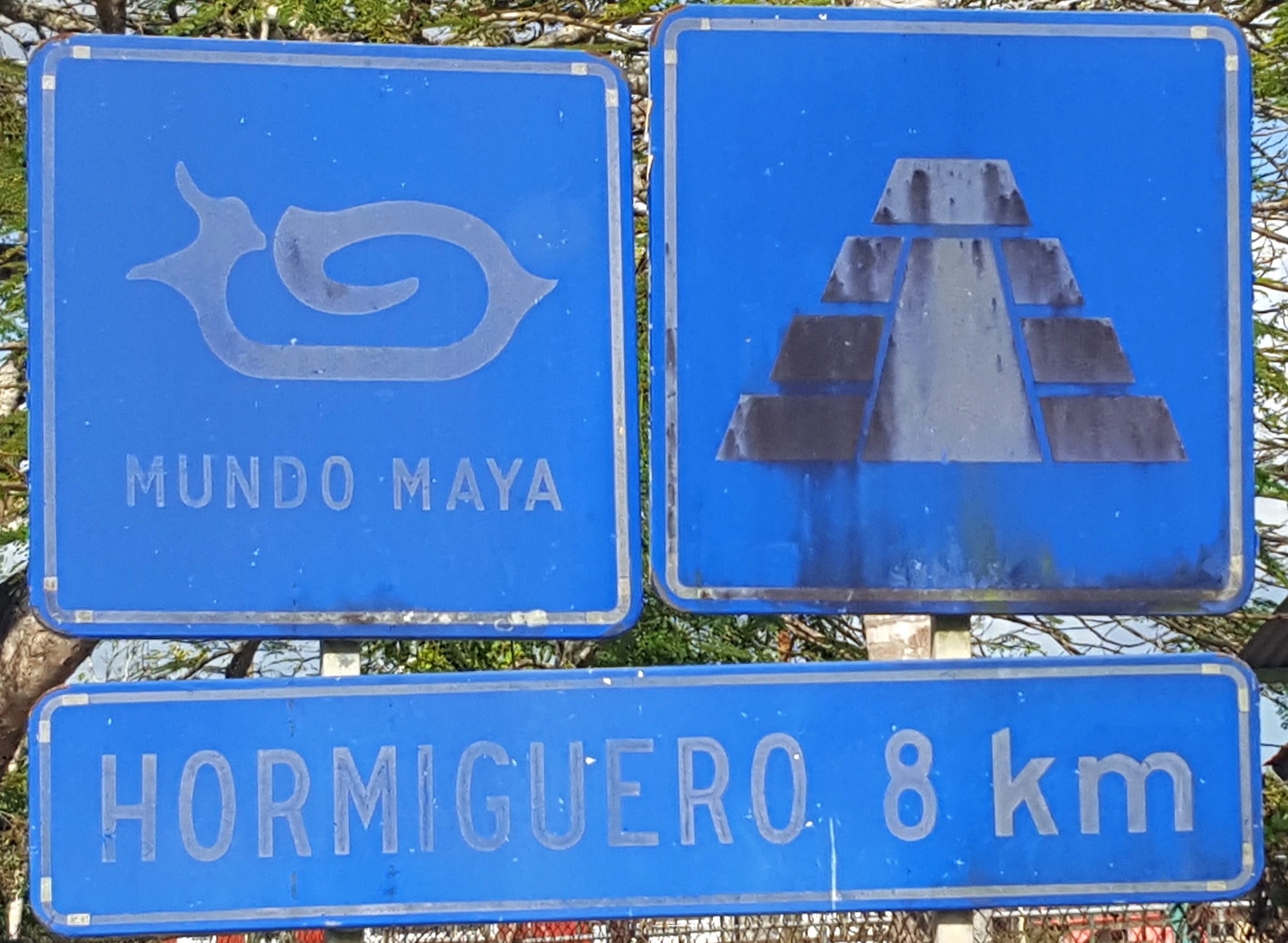 Road sign on Highway 186 directing travellers toward Hormiguero ruins
The yellow diamond warning sign with a bump symbol does exist but is often placed right on top of the tope or missing entirely. Never assume a clear road just because you do not see a sign.
Night Driving
Most federal highways are unlit outside city limits. The practical risks:
- Topes are invisible without streetlights. Hitting a 15 cm tope at 80 km/h will damage suspension or rims.
- Livestock and wildlife — cattle, horses, and dogs roam onto rural roads, especially Fed. 180 (Carmen–Campeche) and Fed. 186 near the biosphere. Nearly impossible to see until the last second.
- Unlit broken-down vehicles — trucks and buses sometimes park in the traffic lane without reflectors.
- Reduced roadside assistance — Ángeles Verdes patrols operate primarily in daylight on libre roads.
Safe at night: Fed. 180D (lit interchanges, regular patrols). Campeche City centro and malecón.
Avoid at night: Fed. 180 between Carmen and Campeche, Fed. 186 between Escárcega and Xpujil, Fed. 261 in rural stretches, Fed. 269 in its entirety. Plan to arrive by 17:00–18:00 if driving these routes.
Rainy Season Driving (June–October)
June averages around 113 mm of rain in Campeche City. Tropical downpours can reduce visibility to near zero, and wipers may not keep up.
Roads most affected:
- Fed. 180 — low stretches near Sabancuy and Isla Aguada can flood; Carmen–Campeche segment develops fast-expanding potholes
- Fed. 269 — poor drainage makes sections impassable
- Calakmul biosphere road — the 60 km dirt road washes out after heavy rain and may close. Visit Calakmul in the dry season (November–April) when possible
Limestone karst terrain means road shoulders can collapse without warning, leaving 10–30 cm drop-offs at the pavement edge. Do not drift right on Fed. 180 or Fed. 269.
Wildlife and Livestock on the Road
Animal encounters are a genuine driving hazard across Campeche, not just a curiosity:
- Calakmul biosphere (Fed. 186 and biosphere road): Jaguar, tapir, peccary, and deer cross the road at dawn and dusk. The entrance gate closes at 15:00 partly to reduce wildlife–vehicle collisions in fading light.
- Fed. 180 coastal (Sabancuy–Isla Aguada): Open-range cattle, horses, and dogs. No fencing.
- Fed. 186 (Escárcega–Xpujil): Cattle and coatis. Roadkill attracts scavengers.
- Fed. 269: Wildlife corridor — narrow road, no shoulders, animals have nowhere to go when a car approaches.
Fuel Availability
Campeche's primary fuel brand is Pemex, with some private stations (BP, Gulf, G500, Oxxo Gas) in larger towns. Magna (regular) runs MXN 24–26 per litre, Premium MXN 26–28. Stations are full-service; a tip of MXN 10–20 is customary. State the bill denomination aloud when paying to avoid a common bill-switching scam.
Critical fuel gaps:
| Stretch | Gap | Last fuel / Next fuel |
|---|---|---|
| Fed. 186: Escárcega → Xpujil | ~150 km | Pemex at Escárcega, next at Xpujil |
| Calakmul biosphere road | Zero | Fill at Xpujil or Conhuas before entering |
| Fed. 269: Hopelchén → Xpujil | ~100 km | Hopelchén town, then Xpujil |
| Fed. 259 (Sabancuy area) | 56 km | Fuel at both ends only |
Card readers frequently fail at rural stations. Carry MXN 1,000–2,000 in cash for fuel. Fill up at half a tank anywhere in rural Campeche.
Police and Military Checkpoints
Expect two types of checkpoints on Campeche highways:
Military checkpoints (Sedena / Guardia Nacional): Sandbagged positions with soldiers in green uniforms. Common on Fed. 186 near the Calakmul turnoff and Fed. 180 east of Carmen. Roughly half of vehicles are waved through. If stopped: come to a complete stop, remain calm, exit if asked, and allow a brief interior inspection (glovebox, trunk, one or two bags). Soldiers are typically courteous but speak limited English.
State police: May check documents, insurance, or conduct sobriety tests, more commonly near cities.
Documents to carry: Passport (or a copy), driver's license (Roman alphabet or IDP), vehicle registration, and Mexican liability insurance. Foreign-plated vehicles also need a Temporary Importation Permit (TIP).
Language tip: Know "¿Adónde va?" (Where are you going?) and "¿De dónde viene?" (Where are you coming from?). A brief, polite answer with your destination is sufficient.
Bribes (mordidas): Rare in Campeche and the Yucatán Peninsula. If hinted at, polite confusion and a request for a written ticket usually ends the conversation.
Firearms and ammunition: Zero tolerance. Even a single stray bullet found in your vehicle is a federal crime. Check your car thoroughly before crossing into Mexico if you drove from the United States.
Navigation and Cell Coverage
Google Maps and Waze work reliably on Fed. 180, 180D, 186, and main Fed. 261 segments. They become unreliable on Fed. 269, the biosphere road, and rural tracks — both may route you onto seasonal roads that are impassable.
Cell coverage gaps:
| Area | Coverage |
|---|---|
| Calakmul Biosphere (entire reserve) | Zero signal, all carriers |
| Fed. 269 (Hopelchén–Xpujil) | Intermittent to none |
| Fed. 186 (Escárcega–Xpujil) | Spotty between towns |
| Fed. 259 (Sabancuy area) | Limited |
Telcel has the widest rural coverage. Download offline maps for your entire route before leaving a city. Maps.me and OsmAnd are reliable offline alternatives.
Driving Culture and Local Norms
A few Mexican driving customs catch visitors off guard:
- Left-turn signal on a highway means "OK to pass me" — not "I am turning left." If you signal left, the car behind assumes you are waving them past. A right-turn signal often means "I am slowing down" or "hazard ahead."
- Hazard lights signal a sudden slowdown, tope ahead, breakdown, or heavy rain.
- Hand signals — a hand out the window pointing indicates a turn; waving means "slow down" or "thank you."
- Roundabouts: Traffic in the circle has priority. Yield on entry.
- Speed limits: Toll roads 110 km/h, libre highways 80 km/h, towns 40 km/h (often unposted). Enforcement is sporadic above 130 km/h.
- Blood alcohol limit: 0.05% in the Yucatán Peninsula — stricter than the national 0.08%.
- Phone use: Handheld is illegal. Use a dashboard mount for GPS.
- Right turn on red: Illegal throughout Mexico.
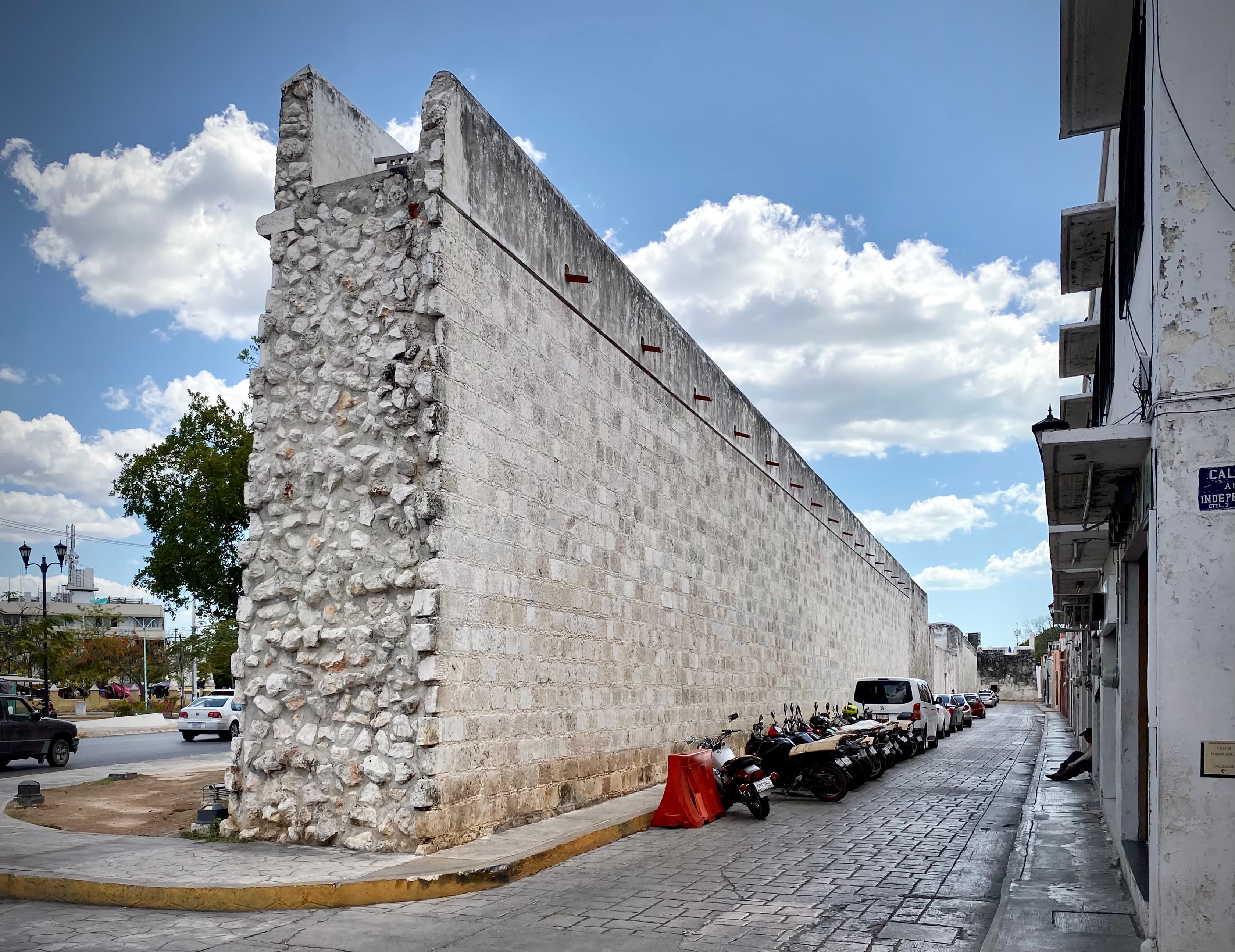
Parking in Campeche City
Parking within the walled centro is limited but manageable:
- White line spaces are free (time limits vary). Yellow line = no parking. Blue line = disabled only.
- Paid lots near Puerta de Tierra and Baluarte San Francisco charge MXN 15–25/hour — the safest option at night.
- Hotels in the centro often provide guest parking.
- Streets inside the walls are narrow, cobbled, and mostly one-way. Do not block residential driveways.

Emergency Numbers
| Service | Number | Notes |
|---|---|---|
| Ángeles Verdes (Green Angels) | 078 | Federal highways and toll roads; 24/7 phone; free labour, pay for parts; bilingual |
| National Emergency | 911 | Police, fire, ambulance |
| State Police (Campeche) | 081 | Statewide |
| Tourist Police (Campeche City) | +52 981 811 9901 | Centro and malecón |
| Red Cross (Campeche) | +52 981 811 9466 | Medical emergencies |
If you break down on a federal highway, pull off the road, lift the hood (universal "need help" signal in Mexico), and call 078. Stay with the vehicle.
Practical Tips
- Use Fed. 180D between Champotón and Campeche City. The MXN 95 toll is worth it — safer, faster, no topes.
- Never enter the Calakmul biosphere without a full tank, water, snacks, offline maps, and a plan to reach the gate before 15:00.
- Avoid Fed. 269 unless visiting Chenes-route ruins and prepared for poor pavement, no fuel, no signal.
- Carry cash for tolls, fuel, tips. Cards fail at rural stations.
- Download offline maps before leaving a city.
- Drive with headlights on on federal highways — expected and improves visibility.
- Plan daylight arrivals. Topes, livestock, and pedestrians in dark clothing are manageable in daylight and significantly riskier after dark.
Need transport? Book a transfer on WhatsApp.