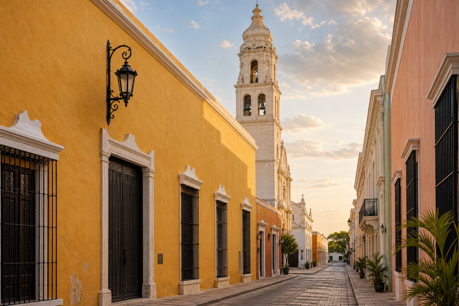

Why Fuerte de San José el Alto deserves a place in your Campeche plans
Fuerte de San José el Alto stands on the highest hill on the northern edge of San Francisco de Campeche, in the neighbourhood that shares its name. From the ramparts you can read the whole defensive geography of the city at once: the Bay of Campeche opening to the north, the low grid of the old walled town, and the coastal plain that attackers would have had to cross. The building is one of the two great hill forts of the city, the counterpart to Fuerte de San Miguel on the opposite side, and it now houses the Museo de Arqueología Subacuática, one of the most unusual museums in Mexico.
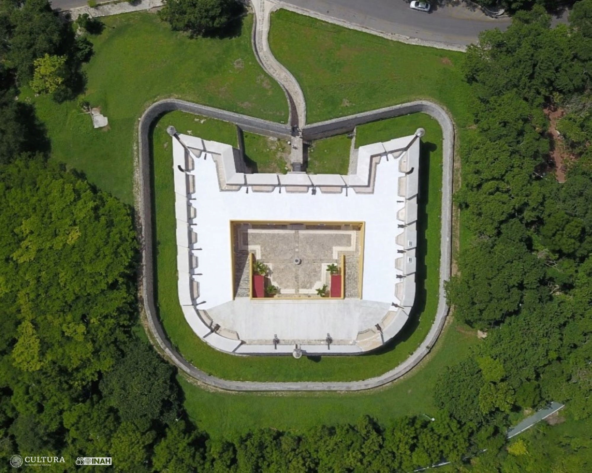
The visit works on two levels. First, there is the building itself: a late eighteenth-century military work with a winding access road, a ditch, vaulted gun decks, a rainwater cistern, and sentry boxes perched on the corners. Second, there is the collection inside: objects raised from shipwrecks, cenotes, rivers, and lagoons across the Gulf of Mexico and the Mexican Caribbean, including gold jewellery and coins recovered from the Alacranes Reef. Few visitors expect a colonial fort on a Gulf hill to hold a national reference collection of underwater archaeology, and that surprise is the main reason the fort rewards more than a photo stop.
 Fuerte de San José el Alto seen across its dry ditch at golden hour, with a corner sentry box and the Bay of Campeche in the distance
Plan on about two hours for the full visit: time on the outer walls and ramparts, then the museum galleries, then a last look at the view. A rushed visit can be done in under an hour, but the fort is a short drive from the centre, so it makes little sense to arrive without enough time to enjoy the building. The hill is exposed, the sun on the ramparts is strong for most of the year, and the galleries are cool and quiet — a combination that works best when you are not watching the clock.
If you like structure and context while you explore, a guided city tour is a reasonable way to see the fortifications with someone who can explain the defensive system as a whole. Compare current Campeche City tours on GetYourGuide and check Viator's Campeche sightseeing listings before your visit. Inventory changes through the season, so use the listings to confirm what is actually operating, and read the itinerary carefully — some city tours pass the forts from the outside only, while others include entry.
GuideBastions of Campeche: San Carlos, San Francisco, San Pedro, Santa Rosa & SantiagoExplore
Where the fort stands and how to get there
The fort sits on the hill known in the colonial period as the Cerro de la Vigía Vieja, the old watch hill, above the neighbourhood of San José el Alto on the northern side of the city. The official address given by INAH is Calle 5 por Avenida Francisco Morazán s/n, Colonia San José el Alto, postal code 24026. In practice, navigation apps handle the name well: enter Fuerte de San José el Alto or Museo de Arqueología Subacuática and the pin is reliable. The approach road climbs from the flat city in a series of curves — a defensive design, not a scenic accident — and the last stretch runs through open grass with the fort ahead of you.
From the historic centre, a taxi or app-based ride takes about ten minutes outside peak traffic. This is the simplest option for most visitors, and it removes the only genuinely difficult part of the visit, which is the climb. Ask to be dropped at the fort entrance, and think about the return before you set off: taxis do not queue at the gate, so either arrange a pickup time with the same driver, use a ride app when you are ready to leave, or walk down to Avenida Francisco Morazán and look for a passing cab from there.
Walking from the centre is possible for a determined and well-prepared visitor, but treat it as a hike rather than a stroll. The distance is manageable; the slope and the sun are the problem. Allow close to an hour from the main square, carry more water than you think you need, start early in the morning, and wear a hat and proper shoes. The sidewalks along parts of the route are narrow, so walk with normal care around traffic. If you are visiting between April and September, when afternoon temperatures in Campeche regularly climb past the mid-thirties, the walk up at midday is a bad idea under almost any circumstances.
If you have a rental car, the fort is straightforward: the hill road starts from the northern avenue grid, signage is adequate, and there is a small parking area at the site. Drivers should note that the access road is steep in places and that the final curves are tight — take them slowly, and watch for pedestrians on the grass verge. Having a car also makes it easy to combine the fort with Fuerte de San Miguel on the other side of the city in a single fort-themed morning, which many visitors find more satisfying than choosing between them.
Public transport exists along the main avenues below the hill, but routes and stop names change, and a bus will still leave you with an uphill walk in the open sun. If you want to try it, confirm the closest stop with your hotel or the driver before boarding rather than trusting a route you found on an old blog post. For most travellers, the small saving is not worth the uncertainty; the taxi fare from the centre is modest.
One practical warning: the neighbourhood below the fort is residential and quiet, which is pleasant, but it means there is no cluster of cafés or shops at the foot of the hill. Bring water, sun protection, and any snacks you need. Eat in the centre before or after your visit rather than planning to find food nearby.
A short history of the fort
The story of San José el Alto begins with a warning letter. In 1777, the governor of San Francisco de Campeche, Antonio Olivier, wrote to King Carlos III of Spain that the city was indefensible against England, whose navy was then the dominant power in the Caribbean and whose commanders had already studied the Gulf coast carefully. The bay's open roadstead and the flat land around the town made a landing plausible, and the existing walls protected the town itself rather than the anchorage. The crown's engineers responded: Agustín Crame, a brigadier of infantry, drew up a defensive project for the plaza that called for six fortifications, of which San José el Alto was one.
Construction took years rather than months and was finished in 1792, under the supervision of José Sabido de Vargas, the lieutenant king — the senior military officer of the province — who governed the work through its final phases. The fort was built on the hill then known as the Cerro de la Vigía Vieja, the old watch hill, whose lookout post it effectively replaced. Locals gave it a second name that still circulates: the Castillo de las Tres Piedras, the castle of the three stones, after a group of large stone slabs beside the building that time has mostly covered.
The fort never fought the battle it was designed for. Britain and Spain shifted between war and uneasy peace, and no English squadron forced the bay. The outworks did their deterrence quietly: two smaller coastal batteries, San Matías and San Lucas, were positioned so that their crossing fields of fire covered the windward shore, the stretches of coast where a landing force would have had the easiest approach. Between them and the hill fort, any attacking squadron would have sailed into overlapping cannon fire before it could put troops ashore.
Its most serious damage came from the Mexican side. In 1842, during Yucatán's separation from Mexico, centralist troops under Antonio López de Santa Anna advanced to besiege Campeche. As the defending Yucatecan forces prepared the city, they ordered the partial demolition of San José el Alto, spiking its usefulness along with the San Matías battery, so that the approaching army could not use the hill fort against the town. INAH's own summary notes that the fort, built to face the English, went on to endure Yucatecan and French sieges in the turbulent middle decades of the nineteenth century before settling into decline.
Rescue came in the twentieth century. INAH and the state government intervened in 1971 and again in 1988, rebuilding roofs and consolidating walls, and for a time the building served as a warehouse for prehispanic and colonial material recovered by archaeological work across the state. In 1995 it opened as the Museo de Barcos y Armas — the museum of boats and arms — and in December 2017 it was renamed the Museo de Arqueología Subacuática when a new hall added the underwater archaeology collection that now defines the visit.
The building itself: what to look for
San José el Alto is smaller than its counterpart San Miguel and deliberately different in character: a compact, squared fort of about 1,829 square metres, without the corner bastions that define the city walls below. Its defences were designed against the weapons of the 1790s, and the design still explains itself if you walk the site in order.
Start with the road you arrive on. The sinuous approach path was an engineering choice, not a scenic one: a straight road would have allowed an attacker to line up a cannon, or to swing a rammed log or metal projectile against the gate, while the curves force any approaching force to expose its flank. The entrance sequence continues the logic — a fixed bridge and a drawbridge over the ditch, then a vaulted entrance passage with the guardroom beside it and the commander's quarters nearby. The main door is made of jabín, a dense local hardwood, reinforced with metal; the material was chosen because it resisted axe and shot far better than soft pine.
 A cantilevered stone sentry box, or garitón, projecting from the corner rampart of Fuerte de San José el Alto
Walk the exterior and count the sentry boxes. The small projecting turrets — garitones — sit at the angles of the walls, each with firing slits that let a sentry cover several directions at once; the overhanging design let defenders watch the base of the wall itself. Inside, the rooms are roofed with continuous barrel vaults of stone, the bóvedas de cañón corrido that gave the garrison protection from bombardment and that keep the galleries noticeably cooler than the ramparts. Around the courtyard the fort organised its working life: the powder magazine kept well away from the kitchen fires, storage rooms, the soldiers' quarters, and the cistern that made the hilltop defensible through a siege.
The ditch is shallow today and partly softened by grass, but from the corner of the terrace you can still read the full geometry: ditch, sloped approach, gate sequence, and the rampart above. Photographers tend to get the best results late in the afternoon, when the low sun brings out the texture of the stone and the ochre paint, and the bay behind the fort turns silver.
Inside the fort: the courtyard and the ramparts
Cross the gate and the fort opens into a square courtyard, the quietest and in many ways the most pleasant space on the hill. The walls around it are painted in the deep ochre that INAH's restorers settled on for the building, the floor is paved in rough flagstone worn by two centuries of boots, and at the centre stands the round stone wellhead of the cistern, which still collects rainwater. Arched doorways lead into the vaulted galleries on all four sides, and a stone staircase climbs to the roof of the range. Because the courtyard is enclosed, it stays a little cooler than the open hill, and it is the natural place to pause between the ramparts and the museum rooms.
 The central courtyard of Fuerte de San José el Alto, seen through a vaulted archway, with the round stone wellhead at its centre
The rampart walk is the other half of the experience. From the roof of the ranges you get the view that justified the fort's existence: the Bay of Campeche stretching north, the low profile of the historic centre with its cathedral towers, the grid of newer neighbourhoods running out towards the ring road, and — on clear days — the opposite hill where Fuerte de San Miguel holds the southern approach. Interpretation is light rather than exhaustive, so it helps to arrive with the basic geography in mind: the town sits a couple of kilometres south, the port installations lie to the northwest, and the flat coastal plain that once worried the engineers runs everywhere between.
Two practical notes about the ramparts. First, there is sun and then there is hilltop sun: the terrace offers little shade except in the sentry boxes, and the stone radiates heat well into the late afternoon. Do the walls first if you arrive in the morning, or leave them for the golden hour if you arrive late. Second, the surfaces are authentic rather than adapted — steps, parapets and uneven flagstones — so watch children on the parapet sides and take care in the occasional slick patch after rain.
The Museo de Arqueología Subacuática: what is in the collection
The museum inside the fort is the reason many travellers rank this above the city's other fort visits, and it deserves better than the ten minutes most itineraries give it. The institution opened in 1995 as a museum of boats and arms, built around the maritime and military history of the port. In December 2017, INAH added the galleries that hold the results of four decades of work by its Subdirección de Arqueología Subacuática — the national underwater archaeology department — and renamed the museum accordingly. The collection gathers objects recovered from submerged contexts across the Gulf of Mexico and the Mexican Caribbean: shipwrecks, but also rivers, lagoons, springs, cenotes, flooded caves and land that the sea has reclaimed along the Yucatán peninsula.
The galleries follow the water. Early rooms deal with navigation and shipbuilding, and they hold one genuinely important object: a bronze half-culverin raised from the Cayo Nuevo I wreck, a sixteenth-century gun considered the oldest cannon of its type in the Western Hemisphere. Nearby sits an ebony ship's tiller, carved and salvaged from a watercourse in Palizada municipality, a reminder that Campeche's underwater heritage reaches far inland through its rivers.
 A gold ring with floral decoration recovered from an unknown shipwreck, displayed in the Museo de Arqueología Subacuática at Fuerte de San José el Alto
The room most visitors remember is the treasure of Alacranes Reef. INAH recovered 211 pieces — gold rings, cufflinks, buttons, pendants, medals, crosses and reliquaries, along with emeralds, an amethyst, a ruby and red coral — from a wreck identified in the reef, thought to be part of a goldsmith's cargo, and the display gathers them under strong lighting in a way that makes the small cases worth a slow walk. A neighbouring case holds macuquina silver coins, the irregular hammer-struck coins of the colonial mint, their crosses and shield stamps still legible. Later rooms trace the technological shift from sail to steam, with porcelain, cutlery, bottles, ship fittings and machinery recovered from more recent wrecks, and the older boat-and-arms collection adds historic weapons from the sixteenth to the nineteenth centuries, a rare cannon raised from the sea, and scale models of notable vessels.
Photography is allowed but flash is prohibited, which is worth knowing before you start: the cases are lit for the naked eye, so steady your phone against the glass or accept a slightly soft image rather than reaching for the flash setting. Room texts are primarily in Spanish; if you want the full context in English, the museum's own visitor guide and audio materials exist, and a guided visit — INAH staff lead them when available — is the most reliable way to get the story of each wreck told properly.
GuidePan de Cazón in Campeche: What It Is & Where to Try ItExplore
Practical visitor information
The essentials, according to INAH's current listing for the site: the fort and museum open Tuesday to Sunday from 8:00 to 17:00, and INAH asks visitors to arrive at least an hour before closing so the galleries and ramparts can be seen properly. The museum closes on Mondays, like most INAH sites, and occasional special closures are announced at short notice, so check the INAH listing or call ahead if your schedule is tight. (Fees and hours do change — verify locally or on the INAH page before you go.)
Admission sits in INAH's mid-range bracket: at last listing, 145 pesos for foreign visitors and 80 pesos for Mexicans and foreign residents, with free entry on Sundays for Mexican nationals and free admission for children under 13, students, teachers and seniors with valid ID. Professional cameras carry a separate fee. Keep small bills for the ticket desk, and remember that the same ticket does not cover Fuerte de San Miguel across town — the two forts are separate admissions.
Services at the site are basic but sufficient: a small parking area, restrooms, and guided visits when staff are available. Rules are the standard INAH museum set — no food or drink inside, no pets, no smoking, no flash photography. There is no shop or café of consequence, so carry water; the hillside grass and the open ramparts give you almost no shade.
Timing is straightforward. Most visitors spend between ninety minutes and two hours on the full circuit — ramparts, galleries, courtyard, then a last pass along the walls. If you are combining the fort with San Miguel in one day, give each its own block rather than rushing both into a single hot afternoon.
Pairing the fort with the rest of Campeche's defences
San José el Alto makes most sense as part of the city's wider defensive system, and a little planning turns three separate visits into one coherent story. The system has three layers. The land walls and sea walls, with their eight bastions, enclosed the town itself — you can walk substantial surviving stretches today, and several bastions now house small museums. The gates, Puerta de Mar towards the sea and Puerta de Tierra inland, controlled every entrance; Puerta de Tierra hosts an evening light-and-sound show that retells the pirate-era story the fortifications were built against. The hill forts — San José el Alto on the north, San Miguel on the south — watched the approaches no wall could cover.
A satisfying one-day pattern, used by plenty of visitors: walk the walled centre and its bastions in the cooler morning hours, break for a long lunch in the centre, then taxi up to San José el Alto in the mid-afternoon when its galleries offer relief from the sun, finish at the ramparts for the late light, and catch the Puerta de Tierra show after dark. If you have a second day, give San Miguel and its Maya archaeology museum its own morning.
If you would rather have the fortifications explained in sequence by a guide, a city tour is a reasonable add-on — some itineraries include the forts, others pass them from the vehicle, so read the description before booking. Compare current Campeche City tours on GetYourGuide and check Viator's Campeche sightseeing listings for what is actually operating during your dates. Inventory shifts through the season, and a listing that mentions "forts" does not always mean interior visits with museum entry — confirm the itinerary details before you reserve.
Where to stay for a forts-focused visit
Base yourself in or near the historic centre rather than close to either fort. Nothing is walkable from the fort hills except the residential neighbourhoods around them, and the centre puts you within a short taxi ride of both hill forts, the bastion museums, the gates, and the evening show — which is exactly the shape of a forts-focused itinerary. The centre also concentrates the city's restaurants and plazas, so the day does not fall apart at meal times.
Check current Campeche City stays on Booking.com · Compare Campeche hotels on Trip.com
Rates in Campeche city are generally moderate by Mexican standards, and the centre's inventory runs from simple guesthouses in restored colonial buildings to international chains on the malecón a few minutes away. If you are driving, confirm parking before booking — the walled streets are narrow, and several central hotels rely on nearby lots rather than their own garages.
Who the fort suits — and who can skip it
San José el Alto rewards some travellers far more than others, and it is worth knowing which kind you are before spending a hot hour of your trip on it.
It suits history-minded visitors first. The building is one of the clearest places in Campeche to read eighteenth-century military engineering — the sinuous road, the gate sequence, the garitones and the vaulted ranges all still explain themselves — and the museum's shipwreck material has no real equivalent in the city. Travellers who enjoy small, focused museums will find the Alacranes Reef gallery alone justifies the trip.
It suits families with a margin of patience in the schedule. Children generally like the ramparts, the sentry boxes and the cannon, and the museum is compact enough to hold younger attention spans — but the surfaces are uneven and the parapets are real, so the visit needs supervision rather than letting the kids range free. The site is small enough that a family can cut it short without feeling the ticket was wasted.
It suits photographers, particularly in the last two hours of daylight, when the ochre walls warm up and the bay behind the fort catches the light. The garita against the sky and the view over the city grid are the two shots most people come for.
Who can reasonably skip it? Travellers with a single day in Campeche who are prioritising the walled centre itself, or using the city purely as a base for Edzná — the centre's bastions and gates will already give you the fortification story. Visitors with limited mobility should think carefully: the access road, the bridge and the rampart stairs involve sustained slopes and steps, and while the courtyard and galleries are more forgiving, the site as a whole was built as a fortress, not adapted as an accessibility-first museum. And anyone deeply averse to heat should schedule carefully or accept that the rampart half of the visit will be brief.
Food, timing and the afternoon plan
Because the hill has no food services, the visit slots most naturally into the part of the day when the city eats anyway. A workable rhythm, refined by many visitors: late lunch in the centre around two or three, when the midday heat peaks and the museums feel far away, a coffee or a rest until four, then the taxi up the hill for the fort's final hours. The galleries are at their most comfortable in late afternoon, the ramparts improve as the sun drops, and you descend into the city just as the malecón and the plazas come alive for the evening.
If you are on a Monday schedule, remember the fort closes and swap in the bastion museums of the centre, which generally keep different rhythms — another reason to confirm current days locally before building a day around either site.
The fort also pairs well with the city's evening programme. The light-and-sound show at Puerta de Tierra runs most evenings — check times locally, as schedules shift with the season — and the sequence of hilltop sunset followed by the illuminated gate makes a tidy narrative arc to a fortifications day.
Fuerte de San José el Alto: frequently asked questions
Is the fort open every day? No. INAH lists the site as open Tuesday to Sunday, 8:00 to 17:00, with Mondays closed like most INAH museums. Special closures happen occasionally, so verify before a tight schedule.
How much time should I allow? Ninety minutes to two hours covers the ramparts, the courtyard and the museum galleries at a comfortable pace. A rushed exterior-only visit can fit inside an hour, but the museum is the point of the site for most visitors, so budget for it.
Can I walk there from the historic centre? Technically yes — it is a long, hot, exposed uphill walk that most people should treat as a hike rather than a stroll. A taxi from the centre takes about ten minutes and costs little; the practical difficulty is the return, since taxis do not queue at the gate, so arrange a pickup or use a ride app.
Is the museum in English? The room texts are primarily in Spanish. INAH publishes a visitor guide and audio materials for the museum, and staff-led guided visits are available when offered — ask at the ticket desk. Travellers who want the full wreck-by-wreck story in English should plan on the guide or a guidebook rather than the wall texts.
Is it worth visiting if I have already seen Fuerte de San Miguel? Yes, and the reverse. The two forts are complements, not duplicates: San Miguel holds the Maya archaeology museum, while San José el Alto holds the underwater archaeology collection and the more complete defensive architecture. Seeing one without the other leaves half the story untold.
Can children visit? Yes — under-13s enter free. The ramparts need close supervision, and the museum's flash rule and glass cases set the usual museum behaviour, but families visit comfortably every week.
How do I get there by public transport? City buses run along the main avenues below the hill, but stops and route numbers change, and any bus still leaves you an uphill walk in the sun. Confirm the current closest stop with your hotel rather than trusting an old blog post; for most travellers the modest taxi fare is the better trade.
Is photography allowed? Yes, without flash. Professional cameras require a separate fee under INAH rules. The treasure cases are lit for the naked eye, so expect to steady your shots against the glass.
GuideBastions of Campeche: San Carlos, San Francisco, San Pedro, Santa Rosa & SantiagoExploreThe bottom line
Give Fuerte de San José el Alto a late-afternoon slot: taxi up from the historic centre around four, walk the ramparts while the sun eases off, work through the underwater archaeology galleries at your own pace, and finish on the walls as the bay turns gold. Pair it with San Miguel on a second day and the walled centre in between, and you will have seen the complete defensive system of one of the Gulf's great fortified ports — with the Alacranes Reef treasure as the detail you will still be describing to people a year later.